Sembung geodata
Sembung (Central Java) is a seat of a fourth-order administrative division; located in Indonesia in Asia/Jakarta (GMT+7) time zone. In our database, there are 407 cities with bigger population. Compared to other cities in Indonesia, 68.4% of cities are located further ↓South; 60.8% of cities are located further →East and 53% of cities have higher elevation than Sembung. Note1


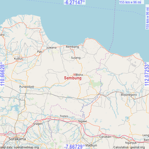
Sembung GPS coordinates[2]
6° 58' 11.64" South, 111° 22' 9.84" East
| Map corner | latitude | longitude |
|---|---|---|
| Upper-left | -6.27147°, | 110.66628° |
| Center: | -6.9699°, | 111.3694° |
| Lower-right: | -7.66729°, | 112.07253° |
| Map W x H: | 155.2×155.2 km | = 96.4×96.4mi |
| max Lat: | 5.88969° ⇑31.6% North |
| Sembung: | -6.9699° |
| min Lat: | ⇓68.4% South -10.934° |
| min Long | Sembung | max Long |
| 95.1345° | 111.3694° | 140.9419° |
| W 39.2%⇐ | ⇒60.8% E |
Elevation
Elevation of Sembung is 92 m = 302 ft, and this is 137.7 m = 452 ft below average elevation for this country.
| Max E: |
3185 m = 10449 ft | 53% |
| Avg. | 229.7 m = 754 ft | |
| Sembung | 92 m = 302 ft | |
Min E: |
-1 m = -3 ft | 47% |
See also: Indonesia elevation on elevation.city.
Geographical zone
Sembung is located in South Torrid zone (between Equator and Tropic of Capricorn). Distance of Equator is 775 km =481.6 mi to North.| Distance of | km | miles | from Sembung |
|---|---|---|---|
| Equator | 775 | 481.6 | to North |
| Tropic Capricorn | 1830.9 | 1137.7 | to South |
| Antarctic Circle | 6626.2 | 4117.3 | to South |
| South Pole | 9232.1 | 5736.6 | to South |


Nearby cities:
15 places around Sembung: (largest is in red/bold)
• Jembangan
2.1 km =1.3 mi,  33°
33°
• Kajangansawan
3.4 km =2.1 mi,  89°
89°
• Kalangan
3.1 km =1.9 mi,  4°
4°
• Karangnongko
3.6 km =2.2 mi,  122°
122°
• Kauman
4.3 km =2.7 mi, 89°
• Kedungringin
2.5 km =1.6 mi,  215°
215°
• Kembang
3.7 km =2.3 mi,  212°
212°
• Kulonkali
2.4 km =1.5 mi,  165°
165°
• Maguwon
0.9 km =0.6 mi,  62°
62°
• Potlot
4.2 km =2.6 mi,  97°
97°
• Sembungin
3.4 km =2.1 mi,  182°
182°
• Sendangsari
4 km =2.5 mi,  251°
251°
• Tawangsari
2.9 km =1.8 mi,  260°
260°
• Triteh
1.4 km =0.9 mi,  323°
323°
• Tutup
2.3 km =1.4 mi, 91°
Sources, notices
• [Note1] Compared only with cities in Indonesia existing in our database
• [Src1] Map data: © OpenStreetMap contributors (CC-BY-SA)
• [Src2] Other city data from geonames.org with taken over terms of usage.
• [Src3] Geographical zone / Annual Mean Temperature by Robert A. Rohde @ Wikipedia
