Ngampel geodata
Ngampel (Central Java) is a seat of a fourth-order administrative division; located in Indonesia in Asia/Jakarta (GMT+7) time zone. In our database, there are 407 cities with bigger population. Compared to other cities in Indonesia, 73.2% of cities are located further ↓South; 59.4% of cities are located further →East and 55% of cities have lower elevation than Ngampel. Note1


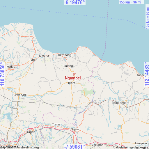
Ngampel GPS coordinates[2]
6° 53' 35.88" South, 111° 26' 30.12" East
| Map corner | latitude | longitude |
|---|---|---|
| Upper-left | -6.19476°, | 110.73858° |
| Center: | -6.8933°, | 111.4417° |
| Lower-right: | -7.59081°, | 112.14483° |
| Map W x H: | 155.2×155.2 km | = 96.4×96.4mi |
| max Lat: | 5.88969° ⇑26.8% North |
| Ngampel: | -6.8933° |
| min Lat: | ⇓73.2% South -10.934° |
| min Long | Ngampel | max Long |
| 95.1345° | 111.4417° | 140.9419° |
| W 40.6%⇐ | ⇒59.4% E |
Elevation
Elevation of Ngampel is 125 m = 410 ft, and this is 104.7 m = 344 ft below average elevation for this country.
| Max E: |
3185 m = 10449 ft | 45% |
| Avg. | 229.7 m = 754 ft | |
| Ngampel | 125 m = 410 ft | |
Min E: |
-1 m = -3 ft | 55% |
See also: Indonesia elevation on elevation.city.
Geographical zone
Ngampel is located in South Torrid zone (between Equator and Tropic of Capricorn). Distance of Equator is 766.5 km =476.3 mi to North.| Distance of | km | miles | from Ngampel |
|---|---|---|---|
| Equator | 766.5 | 476.3 | to North |
| Tropic Capricorn | 1839.5 | 1143 | to South |
| Antarctic Circle | 6634.7 | 4122.6 | to South |
| South Pole | 9240.6 | 5741.8 | to South |


Nearby cities:
15 places around Ngampel: (largest is in red/bold)
• Bacem
4.9 km =3 mi,  140°
140°
• Geneng
3.9 km =2.4 mi,  239°
239°
• Jatirejo
4.5 km =2.8 mi,  132°
132°
• Kadiwono
3.9 km =2.4 mi,  342°
342°
• Kajar
4.5 km =2.8 mi,  73°
73°
• Kalirejo
3.4 km =2.1 mi,  193°
193°
• Karanggeneng
3.6 km =2.2 mi,  164°
164°
• Kebon
4 km =2.5 mi, 339°
• Kemiren
3 km =1.9 mi,  101°
101°
• Medang
2.3 km =1.4 mi, 185°
• Ngadipurwo
2.4 km =1.5 mi,  166°
166°
• Puledagel
5 km =3.1 mi, 157°
• Sitirejo
2.2 km =1.4 mi,  203°
203°
• Tambaksari Satu
4.7 km =2.9 mi, 194°
• Tempuran
3 km =1.9 mi, 133°
Sources, notices
• [Note1] Compared only with cities in Indonesia existing in our database
• [Src1] Map data: © OpenStreetMap contributors (CC-BY-SA)
• [Src2] Other city data from geonames.org with taken over terms of usage.
• [Src3] Geographical zone / Annual Mean Temperature by Robert A. Rohde @ Wikipedia
