Kebon geodata
Kebon (Central Java) is a seat of a fourth-order administrative division; located in Indonesia in Asia/Jakarta (GMT+7) time zone. In our database, there are 407 cities with bigger population. Compared to other cities in Indonesia, 74.6% of cities are located further ↓South; 59.7% of cities are located further →East and 57.7% of cities have lower elevation than Kebon. Note1


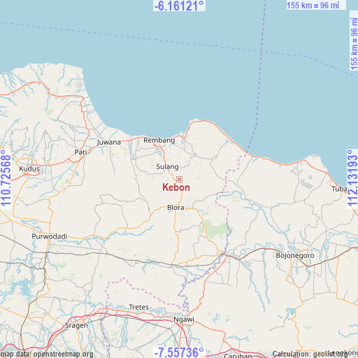
Kebon GPS coordinates[2]
6° 51' 35.28" South, 111° 25' 43.68" East
| Map corner | latitude | longitude |
|---|---|---|
| Upper-left | -6.16121°, | 110.72568° |
| Center: | -6.8598°, | 111.4288° |
| Lower-right: | -7.55736°, | 112.13193° |
| Map W x H: | 155.2×155.2 km | = 96.4×96.4mi |
| max Lat: | 5.88969° ⇑25.4% North |
| Kebon: | -6.8598° |
| min Lat: | ⇓74.6% South -10.934° |
| min Long | Kebon | max Long |
| 95.1345° | 111.4288° | 140.9419° |
| W 40.3%⇐ | ⇒59.7% E |
Elevation
Elevation of Kebon is 143 m = 469 ft, and this is 86.7 m = 284 ft below average elevation for this country.
| Max E: |
3185 m = 10449 ft | 42.3% |
| Avg. | 229.7 m = 754 ft | |
| Kebon | 143 m = 469 ft | |
Min E: |
-1 m = -3 ft | 57.7% |
See also: Indonesia elevation on elevation.city.
Geographical zone
Kebon is located in South Torrid zone (between Equator and Tropic of Capricorn). Distance of Equator is 762.7 km =473.9 mi to North.| Distance of | km | miles | from Kebon |
|---|---|---|---|
| Equator | 762.7 | 473.9 | to North |
| Tropic Capricorn | 1843.2 | 1145.3 | to South |
| Antarctic Circle | 6638.4 | 4124.9 | to South |
| South Pole | 9244.3 | 5744.1 | to South |


Nearby cities:
15 places around Kebon: (largest is in red/bold)
• Banyuurip
5.1 km =3.2 mi,  348°
348°
• Bulu
2.6 km =1.6 mi,  272°
272°
• Demaan
5.9 km =3.7 mi,  1°
1°
• Geneng
6 km =3.7 mi,  198°
198°
• Jukung
3.2 km =2 mi,  306°
306°
• Kadiwono
0.3 km =0.2 mi,  97°
97°
• Ngampel
4 km =2.5 mi,  159°
159°
• Panohan
5.1 km =3.2 mi,  10°
10°
• Pasedan Dua
5.2 km =3.2 mi, 265°
• Pesucen
6 km =3.7 mi,  83°
83°
• Pomahan
5.4 km =3.4 mi,  340°
340°
• Ponjen
5.3 km =3.3 mi,  298°
298°
• Sendangmulyo
5.4 km =3.4 mi,  20°
20°
• Sitirejo
5.8 km =3.6 mi,  174°
174°
• Telgawah
5.9 km =3.7 mi,  28°
28°
Sources, notices
• [Note1] Compared only with cities in Indonesia existing in our database
• [Src1] Map data: © OpenStreetMap contributors (CC-BY-SA)
• [Src2] Other city data from geonames.org with taken over terms of usage.
• [Src3] Geographical zone / Annual Mean Temperature by Robert A. Rohde @ Wikipedia
