Ngundaan geodata
Ngundaan (Central Java) is a seat of a fourth-order administrative division; located in Indonesia in Asia/Jakarta (GMT+7) time zone. In our database, there are 407 cities with bigger population. Compared to other cities in Indonesia, 70.9% of cities are located further ↓South; 60.3% of cities are located further →East and 52% of cities have lower elevation than Ngundaan. Note1


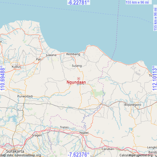
Ngundaan GPS coordinates[2]
6° 55' 34.68" South, 111° 23' 52.8" East
| Map corner | latitude | longitude |
|---|---|---|
| Upper-left | -6.22781°, | 110.69488° |
| Center: | -6.9263°, | 111.398° |
| Lower-right: | -7.62376°, | 112.10113° |
| Map W x H: | 155.2×155.2 km | = 96.4×96.4mi |
| max Lat: | 5.88969° ⇑29.1% North |
| Ngundaan: | -6.9263° |
| min Lat: | ⇓70.9% South -10.934° |
| min Long | Ngundaan | max Long |
| 95.1345° | 111.398° | 140.9419° |
| W 39.7%⇐ | ⇒60.3% E |
Elevation
Elevation of Ngundaan is 110 m = 361 ft, and this is 119.7 m = 393 ft below average elevation for this country.
| Max E: |
3185 m = 10449 ft | 48% |
| Avg. | 229.7 m = 754 ft | |
| Ngundaan | 110 m = 361 ft | |
Min E: |
-1 m = -3 ft | 52% |
See also: Indonesia elevation on elevation.city.
Geographical zone
Ngundaan is located in South Torrid zone (between Equator and Tropic of Capricorn). Distance of Equator is 770.1 km =478.5 mi to North.| Distance of | km | miles | from Ngundaan |
|---|---|---|---|
| Equator | 770.1 | 478.5 | to North |
| Tropic Capricorn | 1835.8 | 1140.7 | to South |
| Antarctic Circle | 6631 | 4120.3 | to South |
| South Pole | 9236.9 | 5739.5 | to South |


Nearby cities:
15 places around Ngundaan: (largest is in red/bold)
• Geneng
2.2 km =1.4 mi,  41°
41°
• Jembangan
3.7 km =2.3 mi,  212°
212°
• Kalangan
3.4 km =2.1 mi,  238°
238°
• Kalirejo
4 km =2.5 mi,  84°
84°
• Karangjati
4.5 km =2.8 mi,  136°
136°
• Kunden
4.3 km =2.7 mi,  159°
159°
• Medang
4.8 km =3 mi,  72°
72°
• Semanten
2.1 km =1.3 mi,  306°
306°
• Sitirejo
4.3 km =2.7 mi, 67°
• Tambaksari Satu
3.7 km =2.3 mi,  103°
103°
• Tegalgunung
4.5 km =2.8 mi,  148°
148°
• Tempelan
4.8 km =3 mi, 156°
• Tunjungan
3.2 km =2 mi,  280°
280°
• Weru
3.3 km =2.1 mi, 136°
• Wonosari
4.8 km =3 mi,  125°
125°
Sources, notices
• [Note1] Compared only with cities in Indonesia existing in our database
• [Src1] Map data: © OpenStreetMap contributors (CC-BY-SA)
• [Src2] Other city data from geonames.org with taken over terms of usage.
• [Src3] Geographical zone / Annual Mean Temperature by Robert A. Rohde @ Wikipedia
