Semanten geodata
Semanten (Central Java) is a seat of a fourth-order administrative division; located in Indonesia in Asia/Jakarta (GMT+7) time zone. In our database, there are 407 cities with bigger population. Compared to other cities in Indonesia, 71.7% of cities are located further ↓South; 60.5% of cities are located further →East and 54.5% of cities have lower elevation than Semanten. Note1


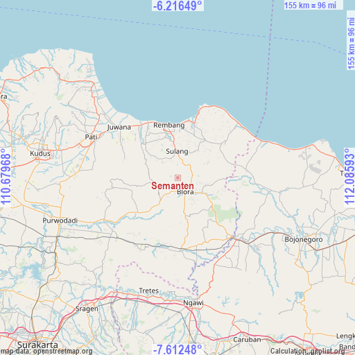
Semanten GPS coordinates[2]
6° 54' 54" South, 111° 22' 58.08" East
| Map corner | latitude | longitude |
|---|---|---|
| Upper-left | -6.21649°, | 110.67968° |
| Center: | -6.915°, | 111.3828° |
| Lower-right: | -7.61248°, | 112.08593° |
| Map W x H: | 155.2×155.2 km | = 96.4×96.4mi |
| max Lat: | 5.88969° ⇑28.3% North |
| Semanten: | -6.915° |
| min Lat: | ⇓71.7% South -10.934° |
| min Long | Semanten | max Long |
| 95.1345° | 111.3828° | 140.9419° |
| W 39.5%⇐ | ⇒60.5% E |
Elevation
Elevation of Semanten is 122 m = 400 ft, and this is 107.7 m = 353 ft below average elevation for this country.
| Max E: |
3185 m = 10449 ft | 45.5% |
| Avg. | 229.7 m = 754 ft | |
| Semanten | 122 m = 400 ft | |
Min E: |
-1 m = -3 ft | 54.5% |
See also: Indonesia elevation on elevation.city.
Geographical zone
Semanten is located in South Torrid zone (between Equator and Tropic of Capricorn). Distance of Equator is 768.9 km =477.8 mi to North.| Distance of | km | miles | from Semanten |
|---|---|---|---|
| Equator | 768.9 | 477.8 | to North |
| Tropic Capricorn | 1837 | 1141.5 | to South |
| Antarctic Circle | 6632.3 | 4121.1 | to South |
| South Pole | 9238.2 | 5740.3 | to South |


Nearby cities:
15 places around Semanten: (largest is in red/bold)
• Geneng
3.2 km =2 mi,  82°
82°
• Jembangan
4.3 km =2.7 mi,  183°
183°
• Kalangan
3.3 km =2.1 mi,  202°
202°
• Kalirejo
5.8 km =3.6 mi,  99°
99°
• Kunden
6.2 km =3.9 mi,  148°
148°
• Maguwon
5.7 km =3.5 mi,  186°
186°
• Medang
6.3 km =3.9 mi,  88°
88°
• Ngundaan
2.1 km =1.3 mi,  126°
126°
• Pasedan Dua
5.8 km =3.6 mi,  358°
358°
• Sitirejo
5.7 km =3.5 mi, 85°
• Tambaksari Satu
5.7 km =3.5 mi,  111°
111°
• Triteh
5.5 km =3.4 mi,  205°
205°
• Tunjungan
1.6 km =1 mi,  245°
245°
• Tutup
6.2 km =3.9 mi,  172°
172°
• Weru
5.3 km =3.3 mi, 132°
Sources, notices
• [Note1] Compared only with cities in Indonesia existing in our database
• [Src1] Map data: © OpenStreetMap contributors (CC-BY-SA)
• [Src2] Other city data from geonames.org with taken over terms of usage.
• [Src3] Geographical zone / Annual Mean Temperature by Robert A. Rohde @ Wikipedia
