Gunungjaya geodata
Gunungjaya (Central Java) is a seat of a fourth-order administrative division; located in Indonesia in Asia/Jakarta (GMT+7) time zone. In our database, there are 407 cities with bigger population. Compared to other cities in Indonesia, 55.9% of cities are located further ↓South; 68.5% of cities are located further →East and 89.3% of cities have lower elevation than Gunungjaya. Note1


Gunungjaya GPS coordinates[2]
7° 11' 0.24" South, 108° 44' 31.2" East
| Map corner | latitude | longitude |
|---|---|---|
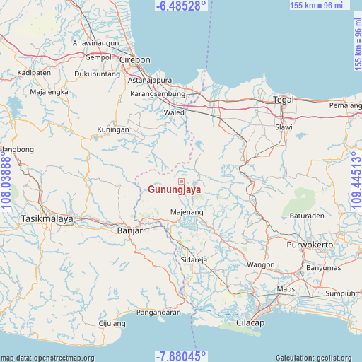
| Upper-left | -6.48528°, | 108.03888° |
| Center: | -7.1834°, | 108.742° |
| Lower-right: | -7.88045°, | 109.44513° |
| Map W x H: | 155.1×155.1 km | = 96.4×96.4mi |
| max Lat: | 5.88969° ⇑44.1% North |
| Gunungjaya: | -7.1834° |
| min Lat: | ⇓55.9% South -10.934° |
| min Long | Gunungjaya | max Long |
| 95.1345° | 108.742° | 140.9419° |
| W 31.5%⇐ | ⇒68.5% E |
Elevation
Elevation of Gunungjaya is 618 m = 2028 ft, and this is 388.3 m = 1274 ft above average elevation for this country.
| Max E: |
3185 m = 10449 ft | 10.7% |
| Gunungjaya | 618 m 2028 ft | |
| Avg. | 229.7 m = 754 ft | |
Min E: |
-1 m = -3 ft | 89.3% |
See also: Indonesia elevation on elevation.city.
Geographical zone
Gunungjaya is located in South Torrid zone (between Equator and Tropic of Capricorn). Distance of Equator is 798.7 km =496.3 mi to North.| Distance of | km | miles | from Gunungjaya |
|---|---|---|---|
| Equator | 798.7 | 496.3 | to North |
| Tropic Capricorn | 1807.2 | 1122.9 | to South |
| Antarctic Circle | 6602.5 | 4102.6 | to South |
| South Pole | 9208.3 | 5721.8 | to South |


Nearby cities:
15 places around Gunungjaya: (largest is in red/bold)
• Balekambang
6 km =3.7 mi,  153°
153°
• Banjaran
6.2 km =3.9 mi,  97°
97°
• Capar
7.2 km =4.5 mi,  352°
352°
• Indrajaya Satu
3.8 km =2.4 mi,  75°
75°
• Kandayakan Satu
6.8 km =4.2 mi,  41°
41°
• Sadabumi
3.5 km =2.2 mi,  164°
164°
• Sadahayu
4.3 km =2.7 mi,  213°
213°
• Salanegara
2.4 km =1.5 mi,  3°
3°
• Salem
7 km =4.3 mi,  89°
89°
• Salem Kidul
6.8 km =4.2 mi, 91°
• Sindangjati
6.7 km =4.2 mi,  178°
178°
• Tembongraja
4.2 km =2.6 mi,  28°
28°
• Ujungbarang Satu
6.2 km =3.9 mi,  130°
130°
• Winduasri
5.1 km =3.2 mi, 348°
• Windusakti Hilir
3.7 km =2.3 mi,  326°
326°
Sources, notices
• [Note1] Compared only with cities in Indonesia existing in our database
• [Src1] Map data: © OpenStreetMap contributors (CC-BY-SA)
• [Src2] Other city data from geonames.org with taken over terms of usage.
• [Src3] Geographical zone / Annual Mean Temperature by Robert A. Rohde @ Wikipedia
