Indrajaya Satu geodata
Indrajaya Satu (Central Java) is a seat of a fourth-order administrative division; located in Indonesia in Asia/Jakarta (GMT+7) time zone. In our database, there are 407 cities with bigger population. Compared to other cities in Indonesia, 56.3% of cities are located further ↓South; 68% of cities are located further →East and 80.6% of cities have lower elevation than Indrajaya Satu. Note1


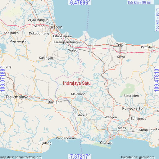
Indrajaya Satu GPS coordinates[2]
7° 10' 30.36" South, 108° 46' 30" East
| Map corner | latitude | longitude |
|---|---|---|
| Upper-left | -6.47696°, | 108.07188° |
| Center: | -7.1751°, | 108.775° |
| Lower-right: | -7.87217°, | 109.47813° |
| Map W x H: | 155.1×155.1 km | = 96.4×96.4mi |
| max Lat: | 5.88969° ⇑43.7% North |
| Indrajaya Satu: | -7.1751° |
| min Lat: | ⇓56.3% South -10.934° |
| min Long | Indrajaya Satu | max Long |
| 95.1345° | 108.775° | 140.9419° |
| W 32%⇐ | ⇒68% E |
Elevation
Elevation of Indrajaya Satu is 441 m = 1447 ft, and this is 211.3 m = 693 ft above average elevation for this country.
| Max E: |
3185 m = 10449 ft | 19.4% |
| Indrajaya Satu | 441 m 1447 ft | |
| Avg. | 229.7 m = 754 ft | |
Min E: |
-1 m = -3 ft | 80.6% |
See also: Indonesia elevation on elevation.city.
Geographical zone
Indrajaya Satu is located in South Torrid zone (between Equator and Tropic of Capricorn). Distance of Equator is 797.8 km =495.7 mi to North.| Distance of | km | miles | from Indrajaya Satu |
|---|---|---|---|
| Equator | 797.8 | 495.7 | to North |
| Tropic Capricorn | 1808.1 | 1123.5 | to South |
| Antarctic Circle | 6603.4 | 4103.2 | to South |
| South Pole | 9209.3 | 5722.4 | to South |


Nearby cities:
15 places around Indrajaya Satu: (largest is in red/bold)
• Banjaran
3 km =1.9 mi,  124°
124°
• Bentar
4.7 km =2.9 mi,  54°
54°
• Bentarsari
5.1 km =3.2 mi,  62°
62°
• Ciputih
5.7 km =3.5 mi,  68°
68°
• Cisitu
4.5 km =2.8 mi,  35°
35°
• Cogreg
4.3 km =2.7 mi, 43°
• Ganggawang
4.8 km =3 mi, 74°
• Gunungjaya
3.8 km =2.4 mi,  255°
255°
• Kandayakan Satu
4.3 km =2.7 mi,  11°
11°
• Sadabumi
5.1 km =3.2 mi,  212°
212°
• Salanegara
3.8 km =2.4 mi,  293°
293°
• Salem
3.5 km =2.2 mi,  103°
103°
• Salem Kidul
3.4 km =2.1 mi,  109°
109°
• Tembongraja
3.3 km =2.1 mi,  329°
329°
• Ujungbarang Satu
5.1 km =3.2 mi,  168°
168°
Sources, notices
• [Note1] Compared only with cities in Indonesia existing in our database
• [Src1] Map data: © OpenStreetMap contributors (CC-BY-SA)
• [Src2] Other city data from geonames.org with taken over terms of usage.
• [Src3] Geographical zone / Annual Mean Temperature by Robert A. Rohde @ Wikipedia
