Jiworejo geodata
Jiworejo (Central Java) is a seat of a fourth-order administrative division; located in Indonesia in Asia/Jakarta (GMT+7) time zone. In our database, there are 407 cities with bigger population. Compared to other cities in Indonesia, 67.5% of cities are located further ↓South; 57.7% of cities are located further →East and 55.8% of cities have lower elevation than Jiworejo. Note1


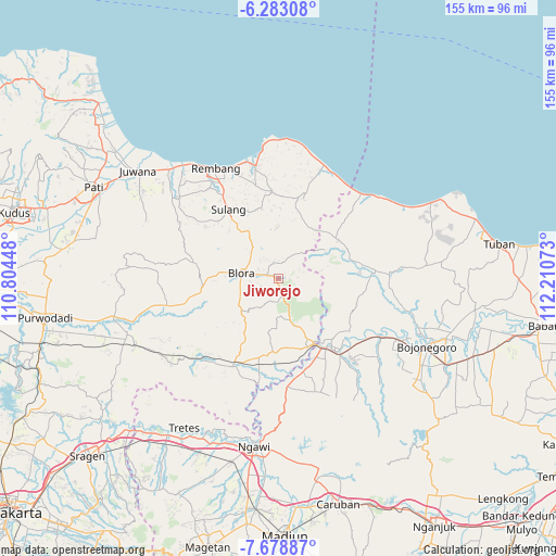
Jiworejo GPS coordinates[2]
6° 58' 53.4" South, 111° 30' 27.36" East
| Map corner | latitude | longitude |
|---|---|---|
| Upper-left | -6.28308°, | 110.80448° |
| Center: | -6.9815°, | 111.5076° |
| Lower-right: | -7.67887°, | 112.21073° |
| Map W x H: | 155.2×155.2 km | = 96.4×96.4mi |
| max Lat: | 5.88969° ⇑32.5% North |
| Jiworejo: | -6.9815° |
| min Lat: | ⇓67.5% South -10.934° |
| min Long | Jiworejo | max Long |
| 95.1345° | 111.5076° | 140.9419° |
| W 42.3%⇐ | ⇒57.7% E |
Elevation
Elevation of Jiworejo is 129 m = 423 ft, and this is 100.7 m = 330 ft below average elevation for this country.
| Max E: |
3185 m = 10449 ft | 44.2% |
| Avg. | 229.7 m = 754 ft | |
| Jiworejo | 129 m = 423 ft | |
Min E: |
-1 m = -3 ft | 55.8% |
See also: Indonesia elevation on elevation.city.
Geographical zone
Jiworejo is located in South Torrid zone (between Equator and Tropic of Capricorn). Distance of Equator is 776.3 km =482.4 mi to North.| Distance of | km | miles | from Jiworejo |
|---|---|---|---|
| Equator | 776.3 | 482.4 | to North |
| Tropic Capricorn | 1829.6 | 1136.9 | to South |
| Antarctic Circle | 6624.9 | 4116.5 | to South |
| South Pole | 9230.8 | 5735.8 | to South |


Nearby cities:
15 places around Jiworejo: (largest is in red/bold)
• Banyubang
3.9 km =2.4 mi,  27°
27°
• Bogorejo
4.7 km =2.9 mi,  14°
14°
• Jepon
3.3 km =2.1 mi,  287°
287°
• Jeponkrajan
3.2 km =2 mi,  275°
275°
• Kemiri
2.5 km =1.6 mi,  243°
243°
• Klampok
2.4 km =1.5 mi,  209°
209°
• Nglarohgunung
3.4 km =2.1 mi,  305°
305°
• Palon
3.6 km =2.2 mi,  220°
220°
• Prantaan
4.1 km =2.5 mi,  345°
345°
• Semampir
2.8 km =1.7 mi,  254°
254°
• Singonegoro
1.9 km =1.2 mi,  76°
76°
• Suruhan
2.7 km =1.7 mi,  160°
160°
• Tempel
1.4 km =0.9 mi, 290°
• Turirejo
4.8 km =3 mi,  262°
262°
• Watulumbung
2.7 km =1.7 mi,  169°
169°
Sources, notices
• [Note1] Compared only with cities in Indonesia existing in our database
• [Src1] Map data: © OpenStreetMap contributors (CC-BY-SA)
• [Src2] Other city data from geonames.org with taken over terms of usage.
• [Src3] Geographical zone / Annual Mean Temperature by Robert A. Rohde @ Wikipedia
