Banyubang geodata
Banyubang (Central Java) is a seat of a fourth-order administrative division; located in Indonesia in Asia/Jakarta (GMT+7) time zone. In our database, there are 407 cities with bigger population. Compared to other cities in Indonesia, 69.6% of cities are located further ↓South; 57.4% of cities are located further →East and 58.2% of cities have lower elevation than Banyubang. Note1


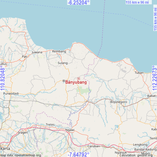
Banyubang GPS coordinates[2]
6° 57' 1.8" South, 111° 31' 24.96" East
| Map corner | latitude | longitude |
|---|---|---|
| Upper-left | -6.25204°, | 110.82048° |
| Center: | -6.9505°, | 111.5236° |
| Lower-right: | -7.64792°, | 112.22673° |
| Map W x H: | 155.2×155.2 km | = 96.4×96.4mi |
| max Lat: | 5.88969° ⇑30.4% North |
| Banyubang: | -6.9505° |
| min Lat: | ⇓69.6% South -10.934° |
| min Long | Banyubang | max Long |
| 95.1345° | 111.5236° | 140.9419° |
| W 42.6%⇐ | ⇒57.4% E |
Elevation
Elevation of Banyubang is 147 m = 482 ft, and this is 82.7 m = 271 ft below average elevation for this country.
| Max E: |
3185 m = 10449 ft | 41.8% |
| Avg. | 229.7 m = 754 ft | |
| Banyubang | 147 m = 482 ft | |
Min E: |
-1 m = -3 ft | 58.2% |
See also: Indonesia elevation on elevation.city.
Geographical zone
Banyubang is located in South Torrid zone (between Equator and Tropic of Capricorn). Distance of Equator is 772.8 km =480.2 mi to North.| Distance of | km | miles | from Banyubang |
|---|---|---|---|
| Equator | 772.8 | 480.2 | to North |
| Tropic Capricorn | 1833.1 | 1139 | to South |
| Antarctic Circle | 6628.4 | 4118.7 | to South |
| South Pole | 9234.2 | 5737.9 | to South |


Nearby cities:
15 places around Banyubang: (largest is in red/bold)
• Blimbing
4.5 km =2.8 mi,  16°
16°
• Bogorejo
1.3 km =0.8 mi,  333°
333°
• Gayamdesa
3.4 km =2.1 mi,  36°
36°
• Gembol
1.7 km =1.1 mi,  75°
75°
• Gombang
4.3 km =2.7 mi,  284°
284°
• Jeruk
2.3 km =1.4 mi,  305°
305°
• Jiworejo
3.9 km =2.4 mi,  207°
207°
• Karang
3.3 km =2.1 mi,  294°
294°
• Karanganyar
4.6 km =2.9 mi,  302°
302°
• Ketringan
4.2 km =2.6 mi,  107°
107°
• Nglengkir
3.7 km =2.3 mi,  338°
338°
• Prantaan
2.9 km =1.8 mi, 279°
• Singonegoro
3 km =1.9 mi,  178°
178°
• Tempel
4.3 km =2.7 mi,  225°
225°
• Wanutengah
2.9 km =1.8 mi,  13°
13°
Sources, notices
• [Note1] Compared only with cities in Indonesia existing in our database
• [Src1] Map data: © OpenStreetMap contributors (CC-BY-SA)
• [Src2] Other city data from geonames.org with taken over terms of usage.
• [Src3] Geographical zone / Annual Mean Temperature by Robert A. Rohde @ Wikipedia
