Krajanbaturno geodata
Krajanbaturno (Central Java) is a seat of a fourth-order administrative division; located in Indonesia in Asia/Jakarta (GMT+7) time zone. In our database, there are 407 cities with bigger population. Compared to other cities in Indonesia, 77.6% of cities are located further ↓South; 55.4% of cities are located further →East and 78.1% of cities have higher elevation than Krajanbaturno. Note1


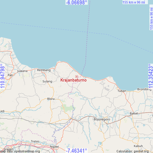
Krajanbaturno GPS coordinates[2]
6° 45' 56.52" South, 111° 39' 3.96" East
| Map corner | latitude | longitude |
|---|---|---|
| Upper-left | -6.06698°, | 110.94798° |
| Center: | -6.7657°, | 111.6511° |
| Lower-right: | -7.46341°, | 112.35423° |
| Map W x H: | 155.3×155.3 km | = 96.5×96.5mi |
| max Lat: | 5.88969° ⇑22.4% North |
| Krajanbaturno: | -6.7657° |
| min Lat: | ⇓77.6% South -10.934° |
| min Long | Krajanbaturno | max Long |
| 95.1345° | 111.6511° | 140.9419° |
| W 44.6%⇐ | ⇒55.4% E |
Elevation
Elevation of Krajanbaturno is 21 m = 69 ft, and this is 208.7 m = 685 ft below average elevation for this country.
| Max E: |
3185 m = 10449 ft | 78.1% |
| Avg. | 229.7 m = 754 ft | |
| Krajanbaturno | 21 m = 69 ft | |
Min E: |
-1 m = -3 ft | 21.9% |
See also: Indonesia elevation on elevation.city.
Geographical zone
Krajanbaturno is located in South Torrid zone (between Equator and Tropic of Capricorn). Distance of Equator is 752.3 km =467.5 mi to North.| Distance of | km | miles | from Krajanbaturno |
|---|---|---|---|
| Equator | 752.3 | 467.5 | to North |
| Tropic Capricorn | 1853.6 | 1151.8 | to South |
| Antarctic Circle | 6648.9 | 4131.4 | to South |
| South Pole | 9254.8 | 5750.7 | to South |


Nearby cities:
15 places around Krajanbaturno: (largest is in red/bold)
• Babak
1 km =0.6 mi,  248°
248°
• Bajingjowo
3.5 km =2.2 mi,  38°
38°
• Bajingmeduro
3.7 km =2.3 mi, 37°
• Banowan
1.7 km =1.1 mi,  53°
53°
• Gonggang
4 km =2.5 mi,  325°
325°
• Karangmangu
3.7 km =2.3 mi, 43°
• Krajanbonjor
2.4 km =1.5 mi,  212°
212°
• Krajandadapmulyo
2.7 km =1.7 mi,  315°
315°
• Sampung
2 km =1.2 mi,  177°
177°
• Sarangmeduro
3.8 km =2.4 mi,  32°
32°
• Sendangmulyo
3.7 km =2.3 mi, 30°
• Tanggulangin
4.2 km =2.6 mi,  274°
274°
• Tawangrejo
3.1 km =1.9 mi, 178°
• Temperak
3.9 km =2.4 mi, 53°
• Tlogoagung
2.5 km =1.6 mi,  122°
122°
Sources, notices
• [Note1] Compared only with cities in Indonesia existing in our database
• [Src1] Map data: © OpenStreetMap contributors (CC-BY-SA)
• [Src2] Other city data from geonames.org with taken over terms of usage.
• [Src3] Geographical zone / Annual Mean Temperature by Robert A. Rohde @ Wikipedia
