Sampung geodata
Sampung (Central Java) is a seat of a fourth-order administrative division; located in Indonesia in Asia/Jakarta (GMT+7) time zone. In our database, there are 407 cities with bigger population. Compared to other cities in Indonesia, 76.9% of cities are located further ↓South; 55.4% of cities are located further →East and 66.1% of cities have higher elevation than Sampung. Note1


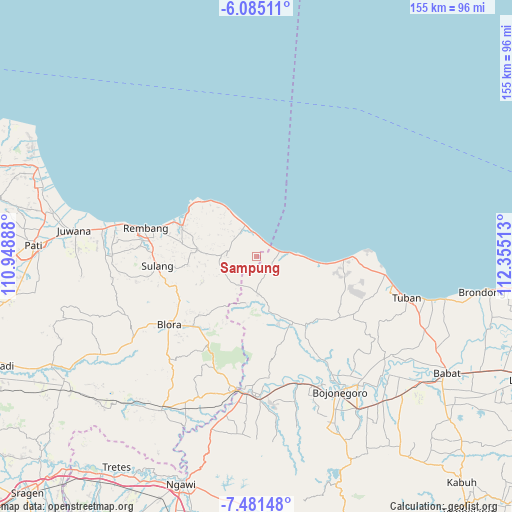
Sampung GPS coordinates[2]
6° 47' 1.68" South, 111° 39' 7.2" East
| Map corner | latitude | longitude |
|---|---|---|
| Upper-left | -6.08511°, | 110.94888° |
| Center: | -6.7838°, | 111.652° |
| Lower-right: | -7.48148°, | 112.35513° |
| Map W x H: | 155.3×155.3 km | = 96.5×96.5mi |
| max Lat: | 5.88969° ⇑23.1% North |
| Sampung: | -6.7838° |
| min Lat: | ⇓76.9% South -10.934° |
| min Long | Sampung | max Long |
| 95.1345° | 111.652° | 140.9419° |
| W 44.6%⇐ | ⇒55.4% E |
Elevation
Elevation of Sampung is 40 m = 131 ft, and this is 189.7 m = 622 ft below average elevation for this country.
| Max E: |
3185 m = 10449 ft | 66.1% |
| Avg. | 229.7 m = 754 ft | |
| Sampung | 40 m = 131 ft | |
Min E: |
-1 m = -3 ft | 33.9% |
See also: Indonesia elevation on elevation.city.
Geographical zone
Sampung is located in South Torrid zone (between Equator and Tropic of Capricorn). Distance of Equator is 754.3 km =468.7 mi to North.| Distance of | km | miles | from Sampung |
|---|---|---|---|
| Equator | 754.3 | 468.7 | to North |
| Tropic Capricorn | 1851.6 | 1150.5 | to South |
| Antarctic Circle | 6646.9 | 4130.2 | to South |
| South Pole | 9252.8 | 5749.4 | to South |


Nearby cities:
15 places around Sampung: (largest is in red/bold)
• Babak
1.9 km =1.2 mi,  329°
329°
• Bajingjowo
5.2 km =3.2 mi,  23°
23°
• Banowan
3.3 km =2.1 mi, 22°
• Karangmangu
5.3 km =3.3 mi,  27°
27°
• Krajan Lodan Kulon
5 km =3.1 mi,  269°
269°
• Krajanbaturno
2 km =1.2 mi,  357°
357°
• Krajanbonjor
1.4 km =0.9 mi, 269°
• Krajandadapmulyo
4.4 km =2.7 mi, 333°
• Latsari
4.4 km =2.7 mi,  82°
82°
• Lodan Wetan
4.8 km =3 mi, 267°
• Selo
5.1 km =3.2 mi,  292°
292°
• Tanggulangin
4.9 km =3 mi,  298°
298°
• Tawangrejo
1.1 km =0.7 mi,  182°
182°
• Temperak
5.3 km =3.3 mi,  35°
35°
• Tlogoagung
2.1 km =1.3 mi,  72°
72°
Sources, notices
• [Note1] Compared only with cities in Indonesia existing in our database
• [Src1] Map data: © OpenStreetMap contributors (CC-BY-SA)
• [Src2] Other city data from geonames.org with taken over terms of usage.
• [Src3] Geographical zone / Annual Mean Temperature by Robert A. Rohde @ Wikipedia
