Sobontoro geodata
Sobontoro (East Java) is a seat of a fourth-order administrative division; located in Indonesia in Asia/Jakarta (GMT+7) time zone. In our database, there are 407 cities with bigger population. Compared to other cities in Indonesia, 76.3% of cities are located further ↓South; 52% of cities are located further →East and 93.7% of cities have higher elevation than Sobontoro. Note1


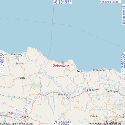
Sobontoro GPS coordinates[2]
6° 48' 2.16" South, 111° 51' 48.6" East
| Map corner | latitude | longitude |
|---|---|---|
| Upper-left | -6.10193°, | 111.16038° |
| Center: | -6.8006°, | 111.8635° |
| Lower-right: | -7.49825°, | 112.56663° |
| Map W x H: | 155.3×155.3 km | = 96.5×96.5mi |
| max Lat: | 5.88969° ⇑23.7% North |
| Sobontoro: | -6.8006° |
| min Lat: | ⇓76.3% South -10.934° |
| min Long | Sobontoro | max Long |
| 95.1345° | 111.8635° | 140.9419° |
| W 48%⇐ | ⇒52% E |
Elevation
Elevation of Sobontoro is 8 m = 26 ft, and this is 221.7 m = 727 ft below average elevation for this country.
| Max E: |
3185 m = 10449 ft | 93.7% |
| Avg. | 229.7 m = 754 ft | |
| Sobontoro | 8 m = 26 ft | |
Min E: |
-1 m = -3 ft | 6.3% |
See also: Indonesia elevation on elevation.city.
Geographical zone
Sobontoro is located in South Torrid zone (between Equator and Tropic of Capricorn). Distance of Equator is 756.2 km =469.9 mi to North.| Distance of | km | miles | from Sobontoro |
|---|---|---|---|
| Equator | 756.2 | 469.9 | to North |
| Tropic Capricorn | 1849.8 | 1149.4 | to South |
| Antarctic Circle | 6645 | 4129 | to South |
| South Pole | 9250.9 | 5748.2 | to South |


Nearby cities:
15 places around Sobontoro: (largest is in red/bold)
• Dukoh
4.9 km =3 mi,  243°
243°
• Gadon
3.3 km =2.1 mi,  268°
268°
• Glondong
3.2 km =2 mi,  73°
73°
• Jamong
0.9 km =0.6 mi,  263°
263°
• Karangasem
3.2 km =2 mi,  100°
100°
• Karangdowo
3.6 km =2.2 mi, 73°
• Karangrejo
3 km =1.9 mi, 267°
• Kenanti
1.6 km =1 mi, 263°
• Klutuk
3.4 km =2.1 mi,  234°
234°
• Merkawang
2.9 km =1.8 mi,  105°
105°
• Mliwang
4.8 km =3 mi,  140°
140°
• Pesantren
2.6 km =1.6 mi, 233°
• Sumberejo
1.4 km =0.9 mi,  146°
146°
• Tanjang
4.8 km =3 mi, 260°
• Tawangrejo
2.3 km =1.4 mi, 264°
Sources, notices
• [Note1] Compared only with cities in Indonesia existing in our database
• [Src1] Map data: © OpenStreetMap contributors (CC-BY-SA)
• [Src2] Other city data from geonames.org with taken over terms of usage.
• [Src3] Geographical zone / Annual Mean Temperature by Robert A. Rohde @ Wikipedia
