Mliwang geodata
Mliwang (East Java) is a seat of a fourth-order administrative division; located in Indonesia in Asia/Jakarta (GMT+7) time zone. In our database, there are 407 cities with bigger population. Compared to other cities in Indonesia, 75.3% of cities are located further ↓South; 51.6% of cities are located further →East and 61.8% of cities have higher elevation than Mliwang. Note1


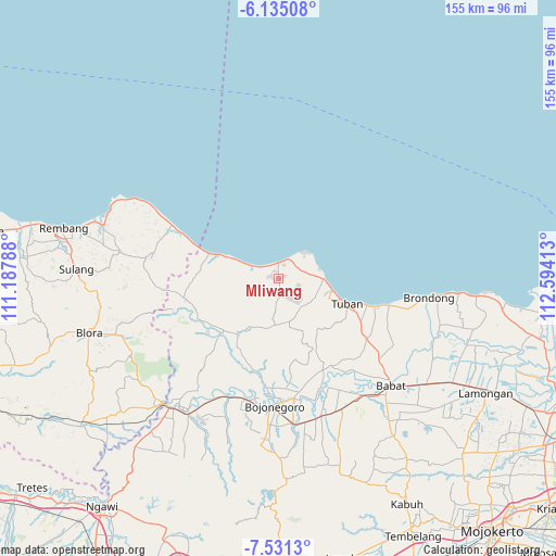
Mliwang GPS coordinates[2]
6° 50' 1.32" South, 111° 53' 27.6" East
| Map corner | latitude | longitude |
|---|---|---|
| Upper-left | -6.13508°, | 111.18788° |
| Center: | -6.8337°, | 111.891° |
| Lower-right: | -7.5313°, | 112.59413° |
| Map W x H: | 155.2×155.2 km | = 96.4×96.4mi |
| max Lat: | 5.88969° ⇑24.7% North |
| Mliwang: | -6.8337° |
| min Lat: | ⇓75.3% South -10.934° |
| min Long | Mliwang | max Long |
| 95.1345° | 111.891° | 140.9419° |
| W 48.4%⇐ | ⇒51.6% E |
Elevation
Elevation of Mliwang is 52 m = 171 ft, and this is 177.7 m = 583 ft below average elevation for this country.
| Max E: |
3185 m = 10449 ft | 61.8% |
| Avg. | 229.7 m = 754 ft | |
| Mliwang | 52 m = 171 ft | |
Min E: |
-1 m = -3 ft | 38.2% |
See also: Indonesia elevation on elevation.city.
Geographical zone
Mliwang is located in South Torrid zone (between Equator and Tropic of Capricorn). Distance of Equator is 759.8 km =472.1 mi to North.| Distance of | km | miles | from Mliwang |
|---|---|---|---|
| Equator | 759.8 | 472.1 | to North |
| Tropic Capricorn | 1846.1 | 1147.1 | to South |
| Antarctic Circle | 6641.3 | 4126.7 | to South |
| South Pole | 9247.2 | 5745.9 | to South |


Nearby cities:
15 places around Mliwang: (largest is in red/bold)
• Glondong
4.6 km =2.9 mi,  0°
0°
• Jamong
5.3 km =3.3 mi,  312°
312°
• Karangasem
3.1 km =1.9 mi, 1°
• Karangdowo
4.7 km =2.9 mi,  5°
5°
• Kasiman
4.5 km =2.8 mi,  186°
186°
• Merkawang
2.9 km =1.8 mi,  355°
355°
• Ngluwuk
5.2 km =3.2 mi,  199°
199°
• Pesantren
5.6 km =3.5 mi,  292°
292°
• Sobontoro
4.8 km =3 mi,  320°
320°
• Sumberarum
4.8 km =3 mi,  178°
178°
• Sumberejo
3.4 km =2.1 mi, 317°
• Temandangjero
5.7 km =3.5 mi,  124°
124°
• Temuji
5.4 km =3.4 mi,  30°
30°
• Tlogowaru
4.2 km =2.6 mi, 120°
• Tobo
4.7 km =2.9 mi,  95°
95°
Sources, notices
• [Note1] Compared only with cities in Indonesia existing in our database
• [Src1] Map data: © OpenStreetMap contributors (CC-BY-SA)
• [Src2] Other city data from geonames.org with taken over terms of usage.
• [Src3] Geographical zone / Annual Mean Temperature by Robert A. Rohde @ Wikipedia
