Jadi geodata
Jadi (East Java) is a seat of a fourth-order administrative division; located in Indonesia in Asia/Jakarta (GMT+7) time zone. In our database, there are 407 cities with bigger population. Compared to other cities in Indonesia, 69% of cities are located further ↓South; 50.1% of cities are located further →East and 64.7% of cities have lower elevation than Jadi. Note1


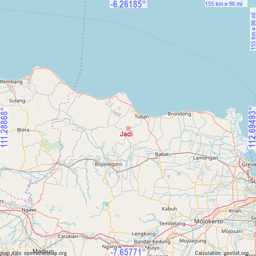
Jadi GPS coordinates[2]
6° 57' 37.08" South, 111° 59' 30.48" East
| Map corner | latitude | longitude |
|---|---|---|
| Upper-left | -6.26185°, | 111.28868° |
| Center: | -6.9603°, | 111.9918° |
| Lower-right: | -7.65771°, | 112.69493° |
| Map W x H: | 155.2×155.2 km | = 96.4×96.4mi |
| max Lat: | 5.88969° ⇑31% North |
| Jadi: | -6.9603° |
| min Lat: | ⇓69% South -10.934° |
| min Long | Jadi | max Long |
| 95.1345° | 111.9918° | 140.9419° |
| W 49.9%⇐ | ⇒50.1% E |
Elevation
Elevation of Jadi is 219 m = 719 ft, and this is 10.7 m = 35 ft below average elevation for this country.
| Max E: |
3185 m = 10449 ft | 35.3% |
| Avg. | 229.7 m = 754 ft | |
| Jadi | 219 m = 719 ft | |
Min E: |
-1 m = -3 ft | 64.7% |
See also: Indonesia elevation on elevation.city.
Geographical zone
Jadi is located in South Torrid zone (between Equator and Tropic of Capricorn). Distance of Equator is 773.9 km =480.9 mi to North.| Distance of | km | miles | from Jadi |
|---|---|---|---|
| Equator | 773.9 | 480.9 | to North |
| Tropic Capricorn | 1832 | 1138.4 | to South |
| Antarctic Circle | 6627.3 | 4118 | to South |
| South Pole | 9233.1 | 5737.2 | to South |


Nearby cities:
15 places around Jadi: (largest is in red/bold)
• Bonggol Satu
6.9 km =4.3 mi,  17°
17°
• Boto
5.1 km =3.2 mi,  12°
12°
• Drudikrajan
8 km =5 mi,  103°
103°
• Gesikan
4.4 km =2.7 mi,  186°
186°
• Jadikrajan
3.7 km =2.3 mi, 20°
• Kapu
8 km =5 mi,  357°
357°
• Kembangbilo
7.5 km =4.7 mi,  32°
32°
• Krajan Dermawuharjo
6.6 km =4.1 mi,  140°
140°
• Krajan Prunggahan Wetan
6.8 km =4.2 mi,  68°
68°
• Pelang
7.2 km =4.5 mi,  1°
1°
• Penambangan
8 km =5 mi, 71°
• Pericik
7.9 km =4.9 mi,  58°
58°
• Sugiharjo
7.1 km =4.4 mi, 22°
• Taraan
6.3 km =3.9 mi, 11°
• Waleran
5.4 km =3.4 mi,  213°
213°
Sources, notices
• [Note1] Compared only with cities in Indonesia existing in our database
• [Src1] Map data: © OpenStreetMap contributors (CC-BY-SA)
• [Src2] Other city data from geonames.org with taken over terms of usage.
• [Src3] Geographical zone / Annual Mean Temperature by Robert A. Rohde @ Wikipedia
