Temandangjero geodata
Temandangjero (East Java) is a seat of a fourth-order administrative division; located in Indonesia in Asia/Jakarta (GMT+7) time zone. In our database, there are 407 cities with bigger population. Compared to other cities in Indonesia, 74.5% of cities are located further ↓South; 50.9% of cities are located further →East and 80.9% of cities have higher elevation than Temandangjero. Note1


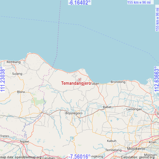
Temandangjero GPS coordinates[2]
6° 51' 45.36" South, 111° 56' 0.6" East
| Map corner | latitude | longitude |
|---|---|---|
| Upper-left | -6.16402°, | 111.23038° |
| Center: | -6.8626°, | 111.9335° |
| Lower-right: | -7.56016°, | 112.63663° |
| Map W x H: | 155.2×155.2 km | = 96.4×96.4mi |
| max Lat: | 5.88969° ⇑25.5% North |
| Temandangjero: | -6.8626° |
| min Lat: | ⇓74.5% South -10.934° |
| min Long | Temandangjero | max Long |
| 95.1345° | 111.9335° | 140.9419° |
| W 49.1%⇐ | ⇒50.9% E |
Elevation
Elevation of Temandangjero is 18 m = 59 ft, and this is 211.7 m = 695 ft below average elevation for this country.
| Max E: |
3185 m = 10449 ft | 80.9% |
| Avg. | 229.7 m = 754 ft | |
| Temandangjero | 18 m = 59 ft | |
Min E: |
-1 m = -3 ft | 19.1% |
See also: Indonesia elevation on elevation.city.
Geographical zone
Temandangjero is located in South Torrid zone (between Equator and Tropic of Capricorn). Distance of Equator is 763 km =474.1 mi to North.| Distance of | km | miles | from Temandangjero |
|---|---|---|---|
| Equator | 763 | 474.1 | to North |
| Tropic Capricorn | 1842.9 | 1145.1 | to South |
| Antarctic Circle | 6638.1 | 4124.7 | to South |
| South Pole | 9244 | 5744 | to South |


Nearby cities:
15 places around Temandangjero: (largest is in red/bold)
• Banaran
2.5 km =1.6 mi,  87°
87°
• Borehbangle
4.1 km =2.5 mi,  96°
96°
• Karangmulyo
4.2 km =2.6 mi,  222°
222°
• Kasiman
5.4 km =3.4 mi,  256°
256°
• Padasan
5.6 km =3.5 mi, 215°
• Pongpongan
1.7 km =1.1 mi,  126°
126°
• Senori
3 km =1.9 mi,  108°
108°
• Sugihan
3.1 km =1.9 mi,  38°
38°
• Sumber
5.5 km =3.4 mi, 86°
• Sumberarum
4.8 km =3 mi,  250°
250°
• Suwalan
5.7 km =3.5 mi,  67°
67°
• Tlogowaru
1.5 km =0.9 mi,  315°
315°
• Tobo
2.8 km =1.7 mi,  358°
358°
• Tuwiri Kulon
4.4 km =2.7 mi, 105°
• Tuwiri Wetan
4.9 km =3 mi, 104°
Sources, notices
• [Note1] Compared only with cities in Indonesia existing in our database
• [Src1] Map data: © OpenStreetMap contributors (CC-BY-SA)
• [Src2] Other city data from geonames.org with taken over terms of usage.
• [Src3] Geographical zone / Annual Mean Temperature by Robert A. Rohde @ Wikipedia
