Gununggede geodata
Gununggede (East Java) is a seat of a fourth-order administrative division; located in Indonesia in Asia/Jakarta (GMT+7) time zone. In our database, there are 407 cities with bigger population. Compared to other cities in Indonesia, 74.5% of cities are located further ↑North; 51.3% of cities are located further ←West and 64.3% of cities have lower elevation than Gununggede. Note1


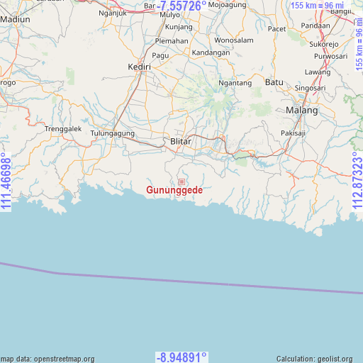
Gununggede GPS coordinates[2]
8° 15' 13.32" South, 112° 10' 12.36" East
| Map corner | latitude | longitude |
|---|---|---|
| Upper-left | -7.55726°, | 111.46698° |
| Center: | -8.2537°, | 112.1701° |
| Lower-right: | -8.94891°, | 112.87323° |
| Map W x H: | 154.7×154.7 km | = 96.1×96.1mi |
| max Lat: | 5.88969° ⇑74.5% North |
| Gununggede: | -8.2537° |
| min Lat: | ⇓25.5% South -10.934° |
| min Long | Gununggede | max Long |
| 95.1345° | 112.1701° | 140.9419° |
| W 51.3%⇐ | ⇒48.7% E |
Elevation
Elevation of Gununggede is 213 m = 699 ft, and this is 16.7 m = 55 ft below average elevation for this country.
| Max E: |
3185 m = 10449 ft | 35.7% |
| Avg. | 229.7 m = 754 ft | |
| Gununggede | 213 m = 699 ft | |
Min E: |
-1 m = -3 ft | 64.3% |
See also: Indonesia elevation on elevation.city.
Geographical zone
Gununggede is located in South Torrid zone (between Equator and Tropic of Capricorn). Distance of Equator is 917.7 km =570.2 mi to North.| Distance of | km | miles | from Gununggede |
|---|---|---|---|
| Equator | 917.7 | 570.2 | to North |
| Tropic Capricorn | 1688.2 | 1049 | to South |
| Antarctic Circle | 6483.4 | 4028.6 | to South |
| South Pole | 9089.3 | 5647.8 | to South |


Nearby cities:
15 places around Gununggede: (largest is in red/bold)
• Becirto
8.5 km =5.3 mi,  69°
69°
• Bendosari
8.1 km =5 mi,  302°
302°
• Kaligrenjeng
5 km =3.1 mi,  243°
243°
• Kalimeneng
9.4 km =5.8 mi,  248°
248°
• Kedungbanteng
8.7 km =5.4 mi,  281°
281°
• Klampok
8.4 km =5.2 mi,  18°
18°
• Lorejo
6 km =3.7 mi,  291°
291°
• Ngadipuro
6.9 km =4.3 mi,  105°
105°
• Ngeni
4.3 km =2.7 mi,  90°
90°
• Pasiraman
4.7 km =2.9 mi, 283°
• Sumberboto Satu
3.8 km =2.4 mi,  318°
318°
• Suruhwadang
9.4 km =5.8 mi,  310°
310°
• Tambakrejo
7 km =4.3 mi,  205°
205°
• Tumpakkepuh
8.1 km =5 mi, 238°
• Wonotirto
3.7 km =2.3 mi,  331°
331°
Sources, notices
• [Note1] Compared only with cities in Indonesia existing in our database
• [Src1] Map data: © OpenStreetMap contributors (CC-BY-SA)
• [Src2] Other city data from geonames.org with taken over terms of usage.
• [Src3] Geographical zone / Annual Mean Temperature by Robert A. Rohde @ Wikipedia
