Tumpakkepuh geodata
Tumpakkepuh (East Java) is a seat of a fourth-order administrative division; located in Indonesia in Asia/Jakarta (GMT+7) time zone. In our database, there are 407 cities with bigger population. Compared to other cities in Indonesia, 76.3% of cities are located further ↑North; 51% of cities are located further ←West and 50% of cities have lower elevation than Tumpakkepuh. Note1


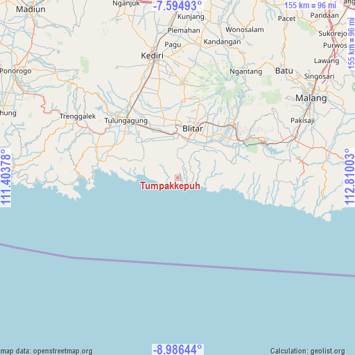
Tumpakkepuh GPS coordinates[2]
8° 17' 28.68" South, 112° 6' 24.84" East
| Map corner | latitude | longitude |
|---|---|---|
| Upper-left | -7.59493°, | 111.40378° |
| Center: | -8.2913°, | 112.1069° |
| Lower-right: | -8.98644°, | 112.81003° |
| Map W x H: | 154.7×154.7 km | = 96.1×96.1mi |
| max Lat: | 5.88969° ⇑76.3% North |
| Tumpakkepuh: | -8.2913° |
| min Lat: | ⇓23.7% South -10.934° |
| min Long | Tumpakkepuh | max Long |
| 95.1345° | 112.1069° | 140.9419° |
| W 51%⇐ | ⇒49% E |
Elevation
Elevation of Tumpakkepuh is 102 m = 335 ft, and this is 127.7 m = 419 ft below average elevation for this country.
| Max E: |
3185 m = 10449 ft | 50% |
| Avg. | 229.7 m = 754 ft | |
| Tumpakkepuh | 102 m = 335 ft | |
Min E: |
-1 m = -3 ft | 50% |
See also: Indonesia elevation on elevation.city.
Geographical zone
Tumpakkepuh is located in South Torrid zone (between Equator and Tropic of Capricorn). Distance of Equator is 921.9 km =572.8 mi to North.| Distance of | km | miles | from Tumpakkepuh |
|---|---|---|---|
| Equator | 921.9 | 572.8 | to North |
| Tropic Capricorn | 1684 | 1046.4 | to South |
| Antarctic Circle | 6479.3 | 4026 | to South |
| South Pole | 9085.2 | 5645.3 | to South |


Nearby cities:
15 places around Tumpakkepuh: (largest is in red/bold)
• Bakung
5.2 km =3.2 mi,  313°
313°
• Bakung Utara
5.8 km =3.6 mi,  316°
316°
• Bendosari
8.5 km =5.3 mi,  0°
0°
• Gununggede
8.1 km =5 mi,  58°
58°
• Kaligrenjeng
3.1 km =1.9 mi,  51°
51°
• Kalimeneng
2 km =1.2 mi,  293°
293°
• Kedungbanteng
6.1 km =3.8 mi,  345°
345°
• Kedunggajul
3.4 km =2.1 mi,  281°
281°
• Lorejo
6.6 km =4.1 mi,  11°
11°
• Ngrejo
6.5 km =4 mi,  334°
334°
• Pasiraman
5.8 km =3.6 mi,  24°
24°
• Sumberboto Satu
8.3 km =5.2 mi,  32°
32°
• Sumberdadi
5.8 km =3.6 mi, 305°
• Tambakrejo
4.5 km =2.8 mi,  119°
119°
• Tumpakoyot
7.6 km =4.7 mi, 287°
Sources, notices
• [Note1] Compared only with cities in Indonesia existing in our database
• [Src1] Map data: © OpenStreetMap contributors (CC-BY-SA)
• [Src2] Other city data from geonames.org with taken over terms of usage.
• [Src3] Geographical zone / Annual Mean Temperature by Robert A. Rohde @ Wikipedia
