Banyutengah geodata
Banyutengah (East Java) is a seat of a fourth-order administrative division; located in Indonesia in Asia/Jakarta (GMT+7) time zone. In our database, there are 407 cities with bigger population. Compared to other cities in Indonesia, 73.3% of cities are located further ↓South; 54.3% of cities are located further ←West and 93.7% of cities have higher elevation than Banyutengah. Note1


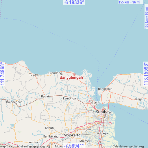
Banyutengah GPS coordinates[2]
6° 53' 30.84" South, 112° 27' 10.08" East
| Map corner | latitude | longitude |
|---|---|---|
| Upper-left | -6.19336°, | 111.74968° |
| Center: | -6.8919°, | 112.4528° |
| Lower-right: | -7.58941°, | 113.15593° |
| Map W x H: | 155.2×155.2 km | = 96.4×96.4mi |
| max Lat: | 5.88969° ⇑26.7% North |
| Banyutengah: | -6.8919° |
| min Lat: | ⇓73.3% South -10.934° |
| min Long | Banyutengah | max Long |
| 95.1345° | 112.4528° | 140.9419° |
| W 54.3%⇐ | ⇒45.7% E |
Elevation
Elevation of Banyutengah is 8 m = 26 ft, and this is 221.7 m = 727 ft below average elevation for this country.
| Max E: |
3185 m = 10449 ft | 93.7% |
| Avg. | 229.7 m = 754 ft | |
| Banyutengah | 8 m = 26 ft | |
Min E: |
-1 m = -3 ft | 6.3% |
See also: Indonesia elevation on elevation.city.
Geographical zone
Banyutengah is located in South Torrid zone (between Equator and Tropic of Capricorn). Distance of Equator is 766.3 km =476.2 mi to North.| Distance of | km | miles | from Banyutengah |
|---|---|---|---|
| Equator | 766.3 | 476.2 | to North |
| Tropic Capricorn | 1839.6 | 1143.1 | to South |
| Antarctic Circle | 6634.9 | 4122.7 | to South |
| South Pole | 9240.8 | 5742 | to South |


Nearby cities:
15 places around Banyutengah: (largest is in red/bold)
• Bluri
4.4 km =2.7 mi,  234°
234°
• Campurrejo
0.8 km =0.5 mi,  0°
0°
• Dagan
5.3 km =3.3 mi,  239°
239°
• Delegan
1.5 km =0.9 mi,  132°
132°
• Gampeng
5 km =3.1 mi,  179°
179°
• Ketanen
3.9 km =2.4 mi,  198°
198°
• Paloh
1.7 km =1.1 mi,  343°
343°
• Pantenan
3.5 km =2.2 mi,  207°
207°
• Prupuh
2.4 km =1.5 mi,  166°
166°
• Sentul
2.7 km =1.7 mi,  294°
294°
• Sidokumpul
1.1 km =0.7 mi, 2°
• Tlogosadang
1.2 km =0.7 mi,  296°
296°
• Waru Lor
1 km =0.6 mi,  10°
10°
• Watuguling
3 km =1.9 mi, 179°
• Weru
1.3 km =0.8 mi,  350°
350°
Sources, notices
• [Note1] Compared only with cities in Indonesia existing in our database
• [Src1] Map data: © OpenStreetMap contributors (CC-BY-SA)
• [Src2] Other city data from geonames.org with taken over terms of usage.
• [Src3] Geographical zone / Annual Mean Temperature by Robert A. Rohde @ Wikipedia
