Prupuh geodata
Prupuh (East Java) is a seat of a third-order administrative division; located in Indonesia in Asia/Jakarta (GMT+7) time zone. In our database, there are 407 cities with bigger population. Compared to other cities in Indonesia, 71.8% of cities are located further ↓South; 54.4% of cities are located further ←West and 77.1% of cities have higher elevation than Prupuh. Note1


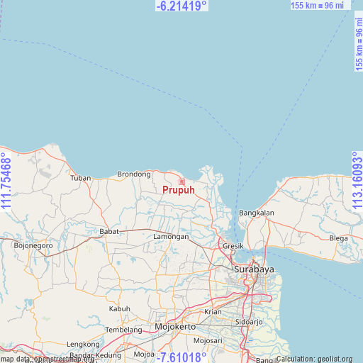
Prupuh GPS coordinates[2]
6° 54' 45.72" South, 112° 27' 28.08" East
| Map corner | latitude | longitude |
|---|---|---|
| Upper-left | -6.21419°, | 111.75468° |
| Center: | -6.9127°, | 112.4578° |
| Lower-right: | -7.61018°, | 113.16093° |
| Map W x H: | 155.2×155.2 km | = 96.4×96.4mi |
| max Lat: | 5.88969° ⇑28.2% North |
| Prupuh: | -6.9127° |
| min Lat: | ⇓71.8% South -10.934° |
| min Long | Prupuh | max Long |
| 95.1345° | 112.4578° | 140.9419° |
| W 54.4%⇐ | ⇒45.6% E |
Elevation
Elevation of Prupuh is 22 m = 72 ft, and this is 207.7 m = 681 ft below average elevation for this country.
| Max E: |
3185 m = 10449 ft | 77.1% |
| Avg. | 229.7 m = 754 ft | |
| Prupuh | 22 m = 72 ft | |
Min E: |
-1 m = -3 ft | 22.9% |
See also: Indonesia elevation on elevation.city.
Geographical zone
Prupuh is located in South Torrid zone (between Equator and Tropic of Capricorn). Distance of Equator is 768.6 km =477.6 mi to North.| Distance of | km | miles | from Prupuh |
|---|---|---|---|
| Equator | 768.6 | 477.6 | to North |
| Tropic Capricorn | 1837.3 | 1141.6 | to South |
| Antarctic Circle | 6632.6 | 4121.3 | to South |
| South Pole | 9238.4 | 5740.5 | to South |


Nearby cities:
15 places around Prupuh: (largest is in red/bold)
• Banyutengah
2.4 km =1.5 mi,  346°
346°
• Bluri
4.1 km =2.5 mi,  267°
267°
• Campurrejo
3.2 km =2 mi, 350°
• Delegan
1.4 km =0.9 mi,  21°
21°
• Gampeng
2.7 km =1.7 mi,  191°
191°
• Ketanen
2.3 km =1.4 mi,  232°
232°
• Paloh
4 km =2.5 mi, 345°
• Pantenan
2.3 km =1.4 mi,  249°
249°
• Serah
4.3 km =2.7 mi,  200°
200°
• Sidokumpul
3.4 km =2.1 mi, 351°
• Siwalan
3.9 km =2.4 mi,  221°
221°
• Tlogosadang
3.3 km =2.1 mi,  330°
330°
• Waru Lor
3.3 km =2.1 mi, 353°
• Watuguling
0.9 km =0.6 mi, 218°
• Weru
3.7 km =2.3 mi, 348°
Sources, notices
• [Note1] Compared only with cities in Indonesia existing in our database
• [Src1] Map data: © OpenStreetMap contributors (CC-BY-SA)
• [Src2] Other city data from geonames.org with taken over terms of usage.
• [Src3] Geographical zone / Annual Mean Temperature by Robert A. Rohde @ Wikipedia
