Delegan geodata
Delegan (East Java) is a seat of a fourth-order administrative division; located in Indonesia in Asia/Jakarta (GMT+7) time zone. In our database, there are 407 cities with bigger population. Compared to other cities in Indonesia, 72.5% of cities are located further ↓South; 54.5% of cities are located further ←West and 85.2% of cities have higher elevation than Delegan. Note1


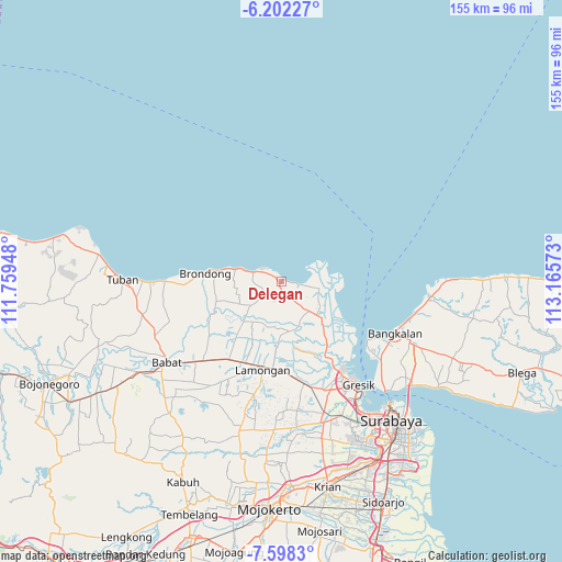
Delegan GPS coordinates[2]
6° 54' 2.88" South, 112° 27' 45.36" East
| Map corner | latitude | longitude |
|---|---|---|
| Upper-left | -6.20227°, | 111.75948° |
| Center: | -6.9008°, | 112.4626° |
| Lower-right: | -7.5983°, | 113.16573° |
| Map W x H: | 155.2×155.2 km | = 96.4×96.4mi |
| max Lat: | 5.88969° ⇑27.5% North |
| Delegan: | -6.9008° |
| min Lat: | ⇓72.5% South -10.934° |
| min Long | Delegan | max Long |
| 95.1345° | 112.4626° | 140.9419° |
| W 54.5%⇐ | ⇒45.5% E |
Elevation
Elevation of Delegan is 14 m = 46 ft, and this is 215.7 m = 708 ft below average elevation for this country.
| Max E: |
3185 m = 10449 ft | 85.2% |
| Avg. | 229.7 m = 754 ft | |
| Delegan | 14 m = 46 ft | |
Min E: |
-1 m = -3 ft | 14.8% |
See also: Indonesia elevation on elevation.city.
Geographical zone
Delegan is located in South Torrid zone (between Equator and Tropic of Capricorn). Distance of Equator is 767.3 km =476.8 mi to North.| Distance of | km | miles | from Delegan |
|---|---|---|---|
| Equator | 767.3 | 476.8 | to North |
| Tropic Capricorn | 1838.6 | 1142.5 | to South |
| Antarctic Circle | 6633.9 | 4122.1 | to South |
| South Pole | 9239.8 | 5741.3 | to South |


Nearby cities:
15 places around Delegan: (largest is in red/bold)
• Banyutengah
1.5 km =0.9 mi,  312°
312°
• Bluri
4.9 km =3 mi,  251°
251°
• Campurrejo
2.1 km =1.3 mi,  329°
329°
• Gampeng
4.1 km =2.5 mi,  194°
194°
• Ketanen
3.6 km =2.2 mi,  220°
220°
• Ngembo
4.5 km =2.8 mi,  101°
101°
• Paloh
3 km =1.9 mi, 328°
• Pantenan
3.4 km =2.1 mi,  231°
231°
• Prupuh
1.4 km =0.9 mi,  201°
201°
• Sentul
4.2 km =2.6 mi,  301°
301°
• Sidokumpul
2.3 km =1.4 mi, 333°
• Tlogosadang
2.7 km =1.7 mi, 305°
• Waru Lor
2.1 km =1.3 mi, 334°
• Watuguling
2.3 km =1.4 mi,  208°
208°
• Weru
2.6 km =1.6 mi, 330°
Sources, notices
• [Note1] Compared only with cities in Indonesia existing in our database
• [Src1] Map data: © OpenStreetMap contributors (CC-BY-SA)
• [Src2] Other city data from geonames.org with taken over terms of usage.
• [Src3] Geographical zone / Annual Mean Temperature by Robert A. Rohde @ Wikipedia
