Depok geodata
Depok (East Java) is a seat of a fourth-order administrative division; located in Indonesia in Asia/Jakarta (GMT+7) time zone. In our database, there are 407 cities with bigger population. Compared to other cities in Indonesia, 70.9% of cities are located further ↑North; 59.4% of cities are located further →East and 86.3% of cities have lower elevation than Depok. Note1


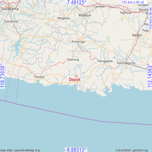
Depok GPS coordinates[2]
8° 11' 16.08" South, 111° 26' 33" East
| Map corner | latitude | longitude |
|---|---|---|
| Upper-left | -7.49125°, | 110.73938° |
| Center: | -8.1878°, | 111.4425° |
| Lower-right: | -8.88313°, | 112.14563° |
| Map W x H: | 154.8×154.8 km | = 96.2×96.2mi |
| max Lat: | 5.88969° ⇑70.9% North |
| Depok: | -8.1878° |
| min Lat: | ⇓29.1% South -10.934° |
| min Long | Depok | max Long |
| 95.1345° | 111.4425° | 140.9419° |
| W 40.6%⇐ | ⇒59.4% E |
Elevation
Elevation of Depok is 541 m = 1775 ft, and this is 311.3 m = 1021 ft above average elevation for this country.
| Max E: |
3185 m = 10449 ft | 13.7% |
| Depok | 541 m 1775 ft | |
| Avg. | 229.7 m = 754 ft | |
Min E: |
-1 m = -3 ft | 86.3% |
See also: Indonesia elevation on elevation.city.
Geographical zone
Depok is located in South Torrid zone (between Equator and Tropic of Capricorn). Distance of Equator is 910.4 km =565.7 mi to North.| Distance of | km | miles | from Depok |
|---|---|---|---|
| Equator | 910.4 | 565.7 | to North |
| Tropic Capricorn | 1695.5 | 1053.5 | to South |
| Antarctic Circle | 6490.8 | 4033.2 | to South |
| South Pole | 9096.7 | 5652.4 | to South |


Nearby cities:
15 places around Depok: (largest is in red/bold)
• Banteng
4.8 km =3 mi,  114°
114°
• Barang
4.3 km =2.7 mi,  141°
141°
• Gayam
5.3 km =3.3 mi,  169°
169°
• Karangtengah
3.3 km =2.1 mi,  209°
209°
• Kebonagung
5.5 km =3.4 mi,  163°
163°
• Kebonsari
3.5 km =2.2 mi,  150°
150°
• Kertosono
3.5 km =2.2 mi, 165°
• Ngangkruk
6.4 km =4 mi, 211°
• Ngrencak
6.1 km =3.8 mi, 157°
• Ngromo
3.1 km =1.9 mi,  238°
238°
• Plalar
4.7 km =2.9 mi,  84°
84°
• Sawahan
4.6 km =2.9 mi,  128°
128°
• Sendang
4.9 km =3 mi,  355°
355°
• Sunduk
2.7 km =1.7 mi,  269°
269°
• Wonodadi
3.5 km =2.2 mi,  23°
23°
Sources, notices
• [Note1] Compared only with cities in Indonesia existing in our database
• [Src1] Map data: © OpenStreetMap contributors (CC-BY-SA)
• [Src2] Other city data from geonames.org with taken over terms of usage.
• [Src3] Geographical zone / Annual Mean Temperature by Robert A. Rohde @ Wikipedia
