Sawahan geodata
Sawahan (East Java) is a seat of a fourth-order administrative division; located in Indonesia in Asia/Jakarta (GMT+7) time zone. In our database, there are 407 cities with bigger population. Compared to other cities in Indonesia, 72.3% of cities are located further ↑North; 58.4% of cities are located further →East and 71.9% of cities have higher elevation than Sawahan. Note1


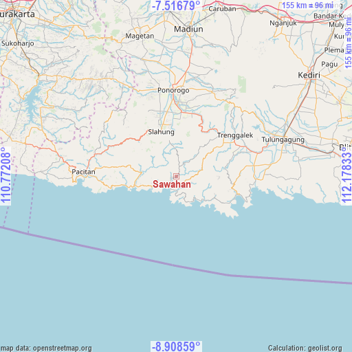
Sawahan GPS coordinates[2]
8° 12' 47.88" South, 111° 28' 30.72" East
| Map corner | latitude | longitude |
|---|---|---|
| Upper-left | -7.51679°, | 110.77208° |
| Center: | -8.2133°, | 111.4752° |
| Lower-right: | -8.90859°, | 112.17833° |
| Map W x H: | 154.8×154.8 km | = 96.2×96.2mi |
| max Lat: | 5.88969° ⇑72.3% North |
| Sawahan: | -8.2133° |
| min Lat: | ⇓27.7% South -10.934° |
| min Long | Sawahan | max Long |
| 95.1345° | 111.4752° | 140.9419° |
| W 41.6%⇐ | ⇒58.4% E |
Elevation
Elevation of Sawahan is 29 m = 95 ft, and this is 200.7 m = 658 ft below average elevation for this country.
| Max E: |
3185 m = 10449 ft | 71.9% |
| Avg. | 229.7 m = 754 ft | |
| Sawahan | 29 m = 95 ft | |
Min E: |
-1 m = -3 ft | 28.1% |
See also: Indonesia elevation on elevation.city.
Geographical zone
Sawahan is located in South Torrid zone (between Equator and Tropic of Capricorn). Distance of Equator is 913.2 km =567.4 mi to North.| Distance of | km | miles | from Sawahan |
|---|---|---|---|
| Equator | 913.2 | 567.4 | to North |
| Tropic Capricorn | 1692.7 | 1051.8 | to South |
| Antarctic Circle | 6487.9 | 4031.4 | to South |
| South Pole | 9093.8 | 5650.6 | to South |


Nearby cities:
15 places around Sawahan: (largest is in red/bold)
• Banteng
1.2 km =0.7 mi,  42°
42°
• Barang
1.1 km =0.7 mi,  241°
241°
• Depok
4.6 km =2.9 mi,  308°
308°
• Gayam
3.6 km =2.2 mi,  227°
227°
• Karangsudo
6 km =3.7 mi,  100°
100°
• Karangtengah
5.2 km =3.2 mi,  269°
269°
• Kebonagung
3.2 km =2 mi,  219°
219°
• Kebonsari
1.9 km =1.2 mi,  264°
264°
• Kertosono
2.8 km =1.7 mi, 258°
• Krajan Ngrambingan
5.4 km =3.4 mi,  163°
163°
• Nglebeng
5.3 km =3.3 mi,  205°
205°
• Ngrencak
3 km =1.9 mi,  203°
203°
• Panggul
4.5 km =2.8 mi, 208°
• Plalar
3.4 km =2.1 mi,  18°
18°
• Wonocoyo Utara
4.8 km =3 mi, 209°
Sources, notices
• [Note1] Compared only with cities in Indonesia existing in our database
• [Src1] Map data: © OpenStreetMap contributors (CC-BY-SA)
• [Src2] Other city data from geonames.org with taken over terms of usage.
• [Src3] Geographical zone / Annual Mean Temperature by Robert A. Rohde @ Wikipedia
