Krajan Puru geodata
Krajan Puru (East Java) is a seat of a fourth-order administrative division; located in Indonesia in Asia/Jakarta (GMT+7) time zone. In our database, there are 407 cities with bigger population. Compared to other cities in Indonesia, 67% of cities are located further ↑North; 56.2% of cities are located further →East and 90.6% of cities have lower elevation than Krajan Puru. Note1


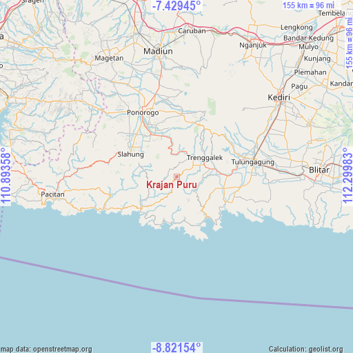
Krajan Puru GPS coordinates[2]
8° 7' 33.96" South, 111° 35' 48.12" East
| Map corner | latitude | longitude |
|---|---|---|
| Upper-left | -7.42945°, | 110.89358° |
| Center: | -8.1261°, | 111.5967° |
| Lower-right: | -8.82154°, | 112.29983° |
| Map W x H: | 154.8×154.8 km | = 96.2×96.2mi |
| max Lat: | 5.88969° ⇑67% North |
| Krajan Puru: | -8.1261° |
| min Lat: | ⇓33% South -10.934° |
| min Long | Krajan Puru | max Long |
| 95.1345° | 111.5967° | 140.9419° |
| W 43.8%⇐ | ⇒56.2% E |
Elevation
Elevation of Krajan Puru is 662 m = 2172 ft, and this is 432.3 m = 1418 ft above average elevation for this country.
| Max E: |
3185 m = 10449 ft | 9.4% |
| Krajan Puru | 662 m 2172 ft | |
| Avg. | 229.7 m = 754 ft | |
Min E: |
-1 m = -3 ft | 90.6% |
See also: Indonesia elevation on elevation.city.
Geographical zone
Krajan Puru is located in South Torrid zone (between Equator and Tropic of Capricorn). Distance of Equator is 903.5 km =561.4 mi to North.| Distance of | km | miles | from Krajan Puru |
|---|---|---|---|
| Equator | 903.5 | 561.4 | to North |
| Tropic Capricorn | 1702.4 | 1057.8 | to South |
| Antarctic Circle | 6497.6 | 4037.4 | to South |
| South Pole | 9103.5 | 5656.7 | to South |


Nearby cities:
15 places around Krajan Puru: (largest is in red/bold)
• Crabak
2.4 km =1.5 mi,  129°
129°
• Gandu
4.1 km =2.5 mi,  10°
10°
• Jatirejo
5.2 km =3.2 mi,  50°
50°
• Krajan Karanganyar
6.1 km =3.8 mi,  321°
321°
• Krajan Pakel
5.7 km =3.5 mi,  255°
255°
• Krajan Pringapus
5.6 km =3.5 mi,  170°
170°
• Krajan Tenggaran
6.5 km =4 mi,  308°
308°
• Krayen
6.7 km =4.2 mi, 49°
• Mloko
5.1 km =3.2 mi,  203°
203°
• Pule
3.9 km =2.4 mi,  273°
273°
• Sidem
3.6 km =2.2 mi,  335°
335°
• Soho
6.4 km =4 mi,  77°
77°
• Tawang
1.4 km =0.9 mi,  29°
29°
• Timahankrajan
6.8 km =4.2 mi,  111°
111°
• Wonokerto
0.6 km =0.4 mi, 51°
Sources, notices
• [Note1] Compared only with cities in Indonesia existing in our database
• [Src1] Map data: © OpenStreetMap contributors (CC-BY-SA)
• [Src2] Other city data from geonames.org with taken over terms of usage.
• [Src3] Geographical zone / Annual Mean Temperature by Robert A. Rohde @ Wikipedia
