Krajan Pakel geodata
Krajan Pakel (East Java) is a seat of a fourth-order administrative division; located in Indonesia in Asia/Jakarta (GMT+7) time zone. In our database, there are 407 cities with bigger population. Compared to other cities in Indonesia, 67.8% of cities are located further ↑North; 57.1% of cities are located further →East and 90.3% of cities have lower elevation than Krajan Pakel. Note1


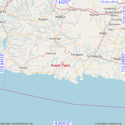
Krajan Pakel GPS coordinates[2]
8° 8' 19.32" South, 111° 32' 46.68" East
| Map corner | latitude | longitude |
|---|---|---|
| Upper-left | -7.44207°, | 110.84318° |
| Center: | -8.1387°, | 111.5463° |
| Lower-right: | -8.83412°, | 112.24943° |
| Map W x H: | 154.8×154.8 km | = 96.2×96.2mi |
| max Lat: | 5.88969° ⇑67.8% North |
| Krajan Pakel: | -8.1387° |
| min Lat: | ⇓32.2% South -10.934° |
| min Long | Krajan Pakel | max Long |
| 95.1345° | 111.5463° | 140.9419° |
| W 42.9%⇐ | ⇒57.1% E |
Elevation
Elevation of Krajan Pakel is 651 m = 2136 ft, and this is 421.3 m = 1382 ft above average elevation for this country.
| Max E: |
3185 m = 10449 ft | 9.7% |
| Krajan Pakel | 651 m 2136 ft | |
| Avg. | 229.7 m = 754 ft | |
Min E: |
-1 m = -3 ft | 90.3% |
See also: Indonesia elevation on elevation.city.
Geographical zone
Krajan Pakel is located in South Torrid zone (between Equator and Tropic of Capricorn). Distance of Equator is 904.9 km =562.3 mi to North.| Distance of | km | miles | from Krajan Pakel |
|---|---|---|---|
| Equator | 904.9 | 562.3 | to North |
| Tropic Capricorn | 1701 | 1057 | to South |
| Antarctic Circle | 6496.2 | 4036.6 | to South |
| South Pole | 9102.1 | 5655.8 | to South |


Nearby cities:
15 places around Krajan Pakel: (largest is in red/bold)
• Dongko
6.3 km =3.9 mi,  150°
150°
• Krajan Dongko
6.6 km =4.1 mi,  144°
144°
• Krajan Joho
3 km =1.9 mi,  227°
227°
• Krajan Karanganyar
6.4 km =4 mi,  15°
15°
• Krajan Petung
6.7 km =4.2 mi,  164°
164°
• Krajan Puru
5.7 km =3.5 mi,  75°
75°
• Krajan Siki
5.1 km =3.2 mi,  193°
193°
• Krajan Tenggaran
5.5 km =3.4 mi,  4°
4°
• Mloko
4.8 km =3 mi,  133°
133°
• Pule
2.3 km =1.4 mi,  45°
45°
• Puyung
5.7 km =3.5 mi,  282°
282°
• Sidem
6.2 km =3.9 mi,  40°
40°
• Tawang
6.8 km =4.2 mi,  67°
67°
• Turi
1.5 km =0.9 mi,  235°
235°
• Wonokerto
6.3 km =3.9 mi, 73°
Sources, notices
• [Note1] Compared only with cities in Indonesia existing in our database
• [Src1] Map data: © OpenStreetMap contributors (CC-BY-SA)
• [Src2] Other city data from geonames.org with taken over terms of usage.
• [Src3] Geographical zone / Annual Mean Temperature by Robert A. Rohde @ Wikipedia
