Blumbang geodata
Blumbang (East Java) is a seat of a fourth-order administrative division; located in Indonesia in Asia/Jakarta (GMT+7) time zone. In our database, there are 407 cities with bigger population. Compared to other cities in Indonesia, 62.1% of cities are located further ↑North; 56.6% of cities are located further →East and 80.7% of cities have lower elevation than Blumbang. Note1


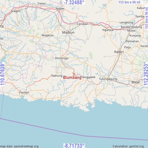
Blumbang GPS coordinates[2]
8° 1' 18.12" South, 111° 34' 45.84" East
| Map corner | latitude | longitude |
|---|---|---|
| Upper-left | -7.32488°, | 110.87628° |
| Center: | -8.0217°, | 111.5794° |
| Lower-right: | -8.71733°, | 112.28253° |
| Map W x H: | 154.8×154.8 km | = 96.2×96.2mi |
| max Lat: | 5.88969° ⇑62.1% North |
| Blumbang: | -8.0217° |
| min Lat: | ⇓37.9% South -10.934° |
| min Long | Blumbang | max Long |
| 95.1345° | 111.5794° | 140.9419° |
| W 43.4%⇐ | ⇒56.6% E |
Elevation
Elevation of Blumbang is 443 m = 1453 ft, and this is 213.3 m = 700 ft above average elevation for this country.
| Max E: |
3185 m = 10449 ft | 19.3% |
| Blumbang | 443 m 1453 ft | |
| Avg. | 229.7 m = 754 ft | |
Min E: |
-1 m = -3 ft | 80.7% |
See also: Indonesia elevation on elevation.city.
Geographical zone
Blumbang is located in South Torrid zone (between Equator and Tropic of Capricorn). Distance of Equator is 891.9 km =554.2 mi to North.| Distance of | km | miles | from Blumbang |
|---|---|---|---|
| Equator | 891.9 | 554.2 | to North |
| Tropic Capricorn | 1714 | 1065 | to South |
| Antarctic Circle | 6509.2 | 4044.6 | to South |
| South Pole | 9115.1 | 5663.9 | to South |


Nearby cities:
15 places around Blumbang: (largest is in red/bold)
• Gajah
3.6 km =2.2 mi,  136°
136°
• Gandu
8 km =5 mi,  160°
160°
• Gondang
2.3 km =1.4 mi,  242°
242°
• Jambu
6.6 km =4.1 mi,  101°
101°
• Krajan Gading
1.6 km =1 mi,  90°
90°
• Krajan Karanganyar
7.1 km =4.4 mi,  195°
195°
• Krajan Nglinggis
3.3 km =2.1 mi,  129°
129°
• Krajan Pucanganak
3.4 km =2.1 mi, 99°
• Krajan Suko Kidul
4.3 km =2.7 mi,  180°
180°
• Krajan Tenggaran
8.2 km =5.1 mi, 202°
• Krajan Winong
7.4 km =4.6 mi, 97°
• Sukorejokrajan
7.4 km =4.6 mi,  106°
106°
• Tegarenkrajan
7.1 km =4.4 mi, 92°
• Tugu
6.2 km =3.9 mi, 94°
• Tumpuk
8.3 km =5.2 mi,  116°
116°
Sources, notices
• [Note1] Compared only with cities in Indonesia existing in our database
• [Src1] Map data: © OpenStreetMap contributors (CC-BY-SA)
• [Src2] Other city data from geonames.org with taken over terms of usage.
• [Src3] Geographical zone / Annual Mean Temperature by Robert A. Rohde @ Wikipedia
