Krajan Suko Kidul geodata
Krajan Suko Kidul (East Java) is a seat of a fourth-order administrative division; located in Indonesia in Asia/Jakarta (GMT+7) time zone. In our database, there are 407 cities with bigger population. Compared to other cities in Indonesia, 63.8% of cities are located further ↑North; 56.6% of cities are located further →East and 86.5% of cities have lower elevation than Krajan Suko Kidul. Note1


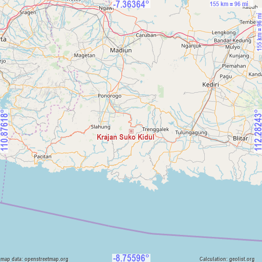
Krajan Suko Kidul GPS coordinates[2]
8° 3' 37.44" South, 111° 34' 45.48" East
| Map corner | latitude | longitude |
|---|---|---|
| Upper-left | -7.36364°, | 110.87618° |
| Center: | -8.0604°, | 111.5793° |
| Lower-right: | -8.75596°, | 112.28243° |
| Map W x H: | 154.8×154.8 km | = 96.2×96.2mi |
| max Lat: | 5.88969° ⇑63.8% North |
| Krajan Suko Kidul: | -8.0604° |
| min Lat: | ⇓36.2% South -10.934° |
| min Long | Krajan Suko Kid | max Long |
| 95.1345° | 111.5793° | 140.9419° |
| W 43.4%⇐ | ⇒56.6% E |
Elevation
Elevation of Krajan Suko Kidul is 546 m = 1791 ft, and this is 316.3 m = 1038 ft above average elevation for this country.
| Max E: |
3185 m = 10449 ft | 13.5% |
| Krajan Suko Kidul | 546 m 1791 ft | |
| Avg. | 229.7 m = 754 ft | |
Min E: |
-1 m = -3 ft | 86.5% |
See also: Indonesia elevation on elevation.city.
Geographical zone
Krajan Suko Kidul is located in South Torrid zone (between Equator and Tropic of Capricorn). Distance of Equator is 896.2 km =556.9 mi to North.| Distance of | km | miles | from Krajan Suko Kidul |
|---|---|---|---|
| Equator | 896.2 | 556.9 | to North |
| Tropic Capricorn | 1709.7 | 1062.4 | to South |
| Antarctic Circle | 6504.9 | 4042 | to South |
| South Pole | 9110.8 | 5661.2 | to South |


Nearby cities:
15 places around Krajan Suko Kidul: (largest is in red/bold)
• Blumbang
4.3 km =2.7 mi,  0°
0°
• Gajah
3 km =1.9 mi,  56°
56°
• Gandu
4.2 km =2.6 mi,  140°
140°
• Gondang
3.8 km =2.4 mi,  327°
327°
• Jambu
7.1 km =4.4 mi,  65°
65°
• Jatirejo
7.1 km =4.4 mi,  124°
124°
• Krajan Gading
4.6 km =2.9 mi,  20°
20°
• Krajan Karanganyar
3.2 km =2 mi,  217°
217°
• Krajan Nglinggis
3.4 km =2.1 mi,  48°
48°
• Krajan Pucanganak
5.1 km =3.2 mi,  42°
42°
• Krajan Tenggaran
4.5 km =2.8 mi, 224°
• Sidem
4 km =2.5 mi,  174°
174°
• Tawang
6.6 km =4.1 mi,  156°
156°
• Tugu
7.3 km =4.5 mi, 58°
• Wonokerto
7.3 km =4.5 mi, 160°
Sources, notices
• [Note1] Compared only with cities in Indonesia existing in our database
• [Src1] Map data: © OpenStreetMap contributors (CC-BY-SA)
• [Src2] Other city data from geonames.org with taken over terms of usage.
• [Src3] Geographical zone / Annual Mean Temperature by Robert A. Rohde @ Wikipedia
