Bendo geodata
Bendo (East Java) is a seat of a third-order administrative division; located in Indonesia in Asia/Jakarta (GMT+7) time zone. In our database, there are 407 cities with bigger population. Compared to other cities in Indonesia, 65.4% of cities are located further ↑North; 53.6% of cities are located further →East and 50.6% of cities have lower elevation than Bendo. Note1


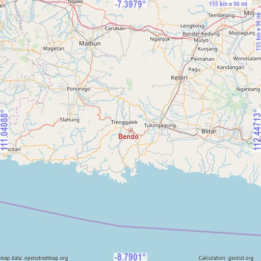
Bendo GPS coordinates[2]
8° 5' 40.56" South, 111° 44' 38.4" East
| Map corner | latitude | longitude |
|---|---|---|
| Upper-left | -7.3979°, | 111.04088° |
| Center: | -8.0946°, | 111.744° |
| Lower-right: | -8.7901°, | 112.44713° |
| Map W x H: | 154.8×154.8 km | = 96.2×96.2mi |
| max Lat: | 5.88969° ⇑65.4% North |
| Bendo: | -8.0946° |
| min Lat: | ⇓34.6% South -10.934° |
| min Long | Bendo | max Long |
| 95.1345° | 111.744° | 140.9419° |
| W 46.4%⇐ | ⇒53.6% E |
Elevation
Elevation of Bendo is 104 m = 341 ft, and this is 125.7 m = 412 ft below average elevation for this country.
| Max E: |
3185 m = 10449 ft | 49.4% |
| Avg. | 229.7 m = 754 ft | |
| Bendo | 104 m = 341 ft | |
Min E: |
-1 m = -3 ft | 50.6% |
See also: Indonesia elevation on elevation.city.
Geographical zone
Bendo is located in South Torrid zone (between Equator and Tropic of Capricorn). Distance of Equator is 900 km =559.2 mi to North.| Distance of | km | miles | from Bendo |
|---|---|---|---|
| Equator | 900 | 559.2 | to North |
| Tropic Capricorn | 1705.9 | 1060 | to South |
| Antarctic Circle | 6501.1 | 4039.6 | to South |
| South Pole | 9107 | 5658.8 | to South |


Nearby cities:
15 places around Bendo: (largest is in red/bold)
• Brongkah
4.2 km =2.6 mi,  121°
121°
• Duwet
1.1 km =0.7 mi,  264°
264°
• Jedung
3 km =1.9 mi,  211°
211°
• Jugang
2.5 km =1.6 mi,  195°
195°
• Jungke
2.7 km =1.7 mi,  157°
157°
• Manggis
4.1 km =2.5 mi,  244°
244°
• Ngepoh
3.4 km =2.1 mi,  304°
304°
• Ngulan Wetan
3.6 km =2.2 mi,  14°
14°
• Ngulankulonkrajan
3.5 km =2.2 mi,  356°
356°
• Sokobanteng
4.2 km =2.6 mi,  291°
291°
• Suwaru
1.6 km =1 mi,  177°
177°
• Tumpang
2.4 km =1.5 mi,  18°
18°
• Wadi Kidul
2 km =1.2 mi,  354°
354°
• Widoro
3.9 km =2.4 mi,  220°
220°
• Wonocoyo
2.6 km =1.6 mi,  251°
251°
Sources, notices
• [Note1] Compared only with cities in Indonesia existing in our database
• [Src1] Map data: © OpenStreetMap contributors (CC-BY-SA)
• [Src2] Other city data from geonames.org with taken over terms of usage.
• [Src3] Geographical zone / Annual Mean Temperature by Robert A. Rohde @ Wikipedia
