Suwaru geodata
Suwaru (East Java) is a seat of a fourth-order administrative division; located in Indonesia in Asia/Jakarta (GMT+7) time zone. In our database, there are 407 cities with bigger population. Compared to other cities in Indonesia, 66.1% of cities are located further ↑North; 53.6% of cities are located further →East and 51.3% of cities have lower elevation than Suwaru. Note1


Suwaru GPS coordinates[2]
8° 6' 30.96" South, 111° 44' 40.92" East
| Map corner | latitude | longitude |
|---|---|---|
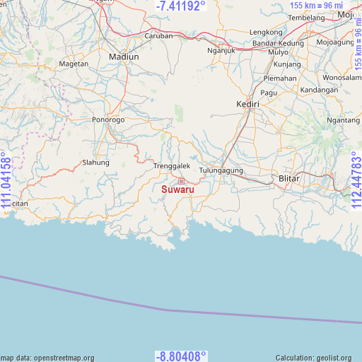
| Upper-left | -7.41192°, | 111.04158° |
| Center: | -8.1086°, | 111.7447° |
| Lower-right: | -8.80408°, | 112.44783° |
| Map W x H: | 154.8×154.8 km | = 96.2×96.2mi |
| max Lat: | 5.88969° ⇑66.1% North |
| Suwaru: | -8.1086° |
| min Lat: | ⇓33.9% South -10.934° |
| min Long | Suwaru | max Long |
| 95.1345° | 111.7447° | 140.9419° |
| W 46.4%⇐ | ⇒53.6% E |
Elevation
Elevation of Suwaru is 107 m = 351 ft, and this is 122.7 m = 403 ft below average elevation for this country.
| Max E: |
3185 m = 10449 ft | 48.7% |
| Avg. | 229.7 m = 754 ft | |
| Suwaru | 107 m = 351 ft | |
Min E: |
-1 m = -3 ft | 51.3% |
See also: Indonesia elevation on elevation.city.
Geographical zone
Suwaru is located in South Torrid zone (between Equator and Tropic of Capricorn). Distance of Equator is 901.6 km =560.2 mi to North.| Distance of | km | miles | from Suwaru |
|---|---|---|---|
| Equator | 901.6 | 560.2 | to North |
| Tropic Capricorn | 1704.3 | 1059 | to South |
| Antarctic Circle | 6499.6 | 4038.7 | to South |
| South Pole | 9105.5 | 5657.9 | to South |


Nearby cities:
15 places around Suwaru: (largest is in red/bold)
• Bendo
1.6 km =1 mi,  357°
357°
• Brongkah
3.5 km =2.2 mi,  100°
100°
• Duwet
1.9 km =1.2 mi,  320°
320°
• Gambang
4.1 km =2.5 mi,  135°
135°
• Jedung
1.9 km =1.2 mi,  239°
239°
• Jugang
1.1 km =0.7 mi,  221°
221°
• Jungke
1.4 km =0.9 mi, 135°
• Manggis
3.7 km =2.3 mi,  266°
266°
• Ngepoh
4.5 km =2.8 mi, 320°
• Sanggar
4.9 km =3 mi, 138°
• Soko
4.7 km =2.9 mi, 143°
• Tumpang
3.9 km =2.4 mi,  9°
9°
• Wadi Kidul
3.6 km =2.2 mi, 355°
• Widoro
2.9 km =1.8 mi, 241°
• Wonocoyo
2.6 km =1.6 mi,  285°
285°
Sources, notices
• [Note1] Compared only with cities in Indonesia existing in our database
• [Src1] Map data: © OpenStreetMap contributors (CC-BY-SA)
• [Src2] Other city data from geonames.org with taken over terms of usage.
• [Src3] Geographical zone / Annual Mean Temperature by Robert A. Rohde @ Wikipedia
