Gambang geodata
Gambang (East Java) is a seat of a fourth-order administrative division; located in Indonesia in Asia/Jakarta (GMT+7) time zone. In our database, there are 407 cities with bigger population. Compared to other cities in Indonesia, 67.6% of cities are located further ↑North; 53.4% of cities are located further →East and 50.6% of cities have higher elevation than Gambang. Note1


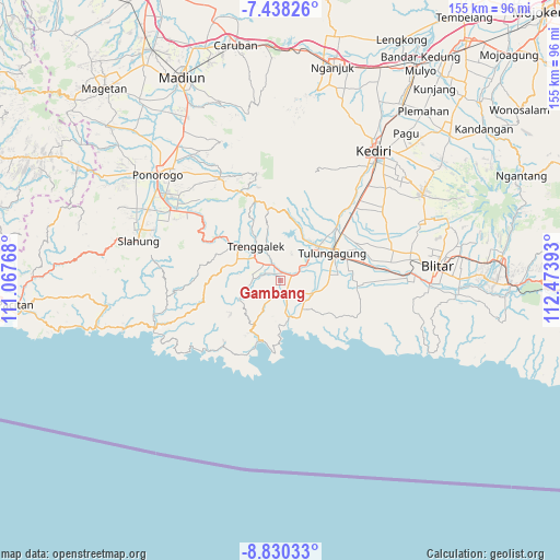
Gambang GPS coordinates[2]
8° 8' 5.64" South, 111° 46' 14.88" East
| Map corner | latitude | longitude |
|---|---|---|
| Upper-left | -7.43826°, | 111.06768° |
| Center: | -8.1349°, | 111.7708° |
| Lower-right: | -8.83033°, | 112.47393° |
| Map W x H: | 154.8×154.8 km | = 96.2×96.2mi |
| max Lat: | 5.88969° ⇑67.6% North |
| Gambang: | -8.1349° |
| min Lat: | ⇓32.4% South -10.934° |
| min Long | Gambang | max Long |
| 95.1345° | 111.7708° | 140.9419° |
| W 46.6%⇐ | ⇒53.4% E |
Elevation
Elevation of Gambang is 100 m = 328 ft, and this is 129.7 m = 426 ft below average elevation for this country.
| Max E: |
3185 m = 10449 ft | 50.6% |
| Avg. | 229.7 m = 754 ft | |
| Gambang | 100 m = 328 ft | |
Min E: |
-1 m = -3 ft | 49.4% |
See also: Indonesia elevation on elevation.city.
Geographical zone
Gambang is located in South Torrid zone (between Equator and Tropic of Capricorn). Distance of Equator is 904.5 km =562 mi to North.| Distance of | km | miles | from Gambang |
|---|---|---|---|
| Equator | 904.5 | 562 | to North |
| Tropic Capricorn | 1701.4 | 1057.2 | to South |
| Antarctic Circle | 6496.7 | 4036.9 | to South |
| South Pole | 9102.5 | 5656 | to South |


Nearby cities:
15 places around Gambang: (largest is in red/bold)
• Bandung
3.9 km =2.4 mi,  157°
157°
• Brongkah
2.4 km =1.5 mi,  14°
14°
• Bulus
1.6 km =1 mi,  128°
128°
• Durenan
3.5 km =2.2 mi,  62°
62°
• Gandong
2.5 km =1.6 mi,  108°
108°
• Jungke
2.7 km =1.7 mi,  315°
315°
• Nglempung
2 km =1.2 mi,  191°
191°
• Randu
3 km =1.9 mi, 55°
• Sambi
3.5 km =2.2 mi,  122°
122°
• Sanggar
0.9 km =0.6 mi,  153°
153°
• Sebalor
3.1 km =1.9 mi,  201°
201°
• Singgit
2.2 km =1.4 mi,  165°
165°
• Soko
0.8 km =0.5 mi, 186°
• Suruhan Lor
2.9 km =1.8 mi,  138°
138°
• Telan
2.8 km =1.7 mi,  82°
82°
Sources, notices
• [Note1] Compared only with cities in Indonesia existing in our database
• [Src1] Map data: © OpenStreetMap contributors (CC-BY-SA)
• [Src2] Other city data from geonames.org with taken over terms of usage.
• [Src3] Geographical zone / Annual Mean Temperature by Robert A. Rohde @ Wikipedia
