Sendung geodata
Sendung (East Java) is a seat of a fourth-order administrative division; located in Indonesia in Asia/Jakarta (GMT+7) time zone. In our database, there are 407 cities with bigger population. Compared to other cities in Indonesia, 62.3% of cities are located further ↑North; 52.1% of cities are located further →East and 51.6% of cities have lower elevation than Sendung. Note1


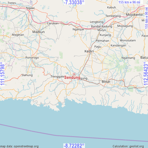
Sendung GPS coordinates[2]
8° 1' 37.92" South, 111° 51' 39.96" East
| Map corner | latitude | longitude |
|---|---|---|
| Upper-left | -7.33038°, | 111.15798° |
| Center: | -8.0272°, | 111.8611° |
| Lower-right: | -8.72282°, | 112.56423° |
| Map W x H: | 154.8×154.8 km | = 96.2×96.2mi |
| max Lat: | 5.88969° ⇑62.3% North |
| Sendung: | -8.0272° |
| min Lat: | ⇓37.7% South -10.934° |
| min Long | Sendung | max Long |
| 95.1345° | 111.8611° | 140.9419° |
| W 47.9%⇐ | ⇒52.1% E |
Elevation
Elevation of Sendung is 108 m = 354 ft, and this is 121.7 m = 399 ft below average elevation for this country.
| Max E: |
3185 m = 10449 ft | 48.4% |
| Avg. | 229.7 m = 754 ft | |
| Sendung | 108 m = 354 ft | |
Min E: |
-1 m = -3 ft | 51.6% |
See also: Indonesia elevation on elevation.city.
Geographical zone
Sendung is located in South Torrid zone (between Equator and Tropic of Capricorn). Distance of Equator is 892.5 km =554.6 mi to North.| Distance of | km | miles | from Sendung |
|---|---|---|---|
| Equator | 892.5 | 554.6 | to North |
| Tropic Capricorn | 1713.4 | 1064.7 | to South |
| Antarctic Circle | 6508.6 | 4044.3 | to South |
| South Pole | 9114.5 | 5663.5 | to South |


Nearby cities:
15 places around Sendung: (largest is in red/bold)
• Banaran
0.9 km =0.6 mi,  139°
139°
• Bolorejo
2.9 km =1.8 mi,  176°
176°
• Boneng
2.5 km =1.6 mi,  163°
163°
• Bungur
3 km =1.9 mi,  89°
89°
• Irongganan
2.8 km =1.7 mi, 156°
• Jabon
1.6 km =1 mi,  122°
122°
• Kalangbret
2.9 km =1.8 mi,  170°
170°
• Kleben
3.5 km =2.2 mi,  221°
221°
• Mojasari
2.1 km =1.3 mi, 177°
• Pucangan
2.1 km =1.3 mi,  232°
232°
• Setonobendo
2.6 km =1.6 mi,  68°
68°
• Srabah
1.9 km =1.2 mi, 224°
• Sukowidodo Barat
3.7 km =2.3 mi,  62°
62°
• Tamanan
3.6 km =2.2 mi,  83°
83°
• Wonokromo
3.5 km =2.2 mi,  201°
201°
Sources, notices
• [Note1] Compared only with cities in Indonesia existing in our database
• [Src1] Map data: © OpenStreetMap contributors (CC-BY-SA)
• [Src2] Other city data from geonames.org with taken over terms of usage.
• [Src3] Geographical zone / Annual Mean Temperature by Robert A. Rohde @ Wikipedia
