Grujugan geodata
Grujugan (East Java) is a seat of a fourth-order administrative division; located in Indonesia in Asia/Jakarta (GMT+7) time zone. In our database, there are 407 cities with bigger population. Compared to other cities in Indonesia, 58.7% of cities are located further ↓South; 62.7% of cities are located further ←West and 65.2% of cities have higher elevation than Grujugan. Note1


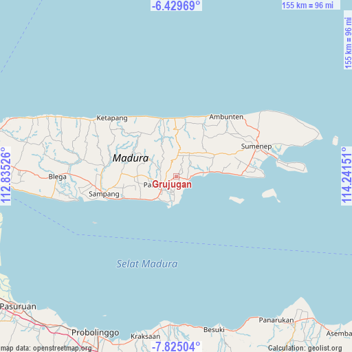
Grujugan GPS coordinates[2]
7° 7' 40.44" South, 113° 32' 18.168" East
| Map corner | latitude | longitude |
|---|---|---|
| Upper-left | -6.42969°, | 112.83526° |
| Center: | -7.1279°, | 113.53838° |
| Lower-right: | -7.82504°, | 114.24151° |
| Map W x H: | 155.1×155.2 km | = 96.4×96.4mi |
| max Lat: | 5.88969° ⇑41.3% North |
| Grujugan: | -7.1279° |
| min Lat: | ⇓58.7% South -10.934° |
| min Long | Grujugan | max Long |
| 95.1345° | 113.53838° | 140.9419° |
| W 62.7%⇐ | ⇒37.3% E |
Elevation
Elevation of Grujugan is 42 m = 138 ft, and this is 187.7 m = 616 ft below average elevation for this country.
| Max E: |
3185 m = 10449 ft | 65.2% |
| Avg. | 229.7 m = 754 ft | |
| Grujugan | 42 m = 138 ft | |
Min E: |
-1 m = -3 ft | 34.8% |
See also: Indonesia elevation on elevation.city.
Geographical zone
Grujugan is located in South Torrid zone (between Equator and Tropic of Capricorn). Distance of Equator is 792.5 km =492.4 mi to North.| Distance of | km | miles | from Grujugan |
|---|---|---|---|
| Equator | 792.5 | 492.4 | to North |
| Tropic Capricorn | 1813.4 | 1126.8 | to South |
| Antarctic Circle | 6608.6 | 4106.4 | to South |
| South Pole | 9214.5 | 5725.6 | to South |


Nearby cities:
15 places around Grujugan: (largest is in red/bold)
• Barajalan
0.7 km =0.4 mi,  214°
214°
• Batuputih
1.9 km =1.2 mi,  55°
55°
• Bertah
1.8 km =1.1 mi,  38°
38°
• Bulay
2 km =1.2 mi,  145°
145°
• Duwaktenggi
2.3 km =1.4 mi,  325°
325°
• Larangan
1 km =0.6 mi,  95°
95°
• Pancoran
3.4 km =2.1 mi,  323°
323°
• Pandiyan
2.2 km =1.4 mi, 100°
• Polagan Tengah
2.7 km =1.7 mi,  115°
115°
• Rongrongan
2.7 km =1.7 mi,  203°
203°
• Tandes
3.3 km =2.1 mi,  175°
175°
• Temorlorong
2.1 km =1.3 mi,  251°
251°
• Tentenan
0.6 km =0.4 mi,  243°
243°
• Toampar
0.6 km =0.4 mi,  127°
127°
• Trasak
1.7 km =1.1 mi, 253°
Sources, notices
• [Note1] Compared only with cities in Indonesia existing in our database
• [Src1] Map data: © OpenStreetMap contributors (CC-BY-SA)
• [Src2] Other city data from geonames.org with taken over terms of usage.
• [Src3] Geographical zone / Annual Mean Temperature by Robert A. Rohde @ Wikipedia
