Tanahmerah geodata
Tanahmerah (East Java) is a seat of a fourth-order administrative division; located in Indonesia in Asia/Jakarta (GMT+7) time zone. In our database, there are 407 cities with bigger population. Compared to other cities in Indonesia, 58.4% of cities are located further ↓South; 63.2% of cities are located further ←West and 78.1% of cities have higher elevation than Tanahmerah. Note1


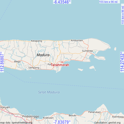
Tanahmerah GPS coordinates[2]
7° 8' 1.176" South, 113° 34' 16.284" East
| Map corner | latitude | longitude |
|---|---|---|
| Upper-left | -6.43546°, | 112.86807° |
| Center: | -7.13366°, | 113.57119° |
| Lower-right: | -7.83079°, | 114.27432° |
| Map W x H: | 155.1×155.1 km | = 96.4×96.4mi |
| max Lat: | 5.88969° ⇑41.6% North |
| Tanahmerah: | -7.13366° |
| min Lat: | ⇓58.4% South -10.934° |
| min Long | Tanahmerah | max Long |
| 95.1345° | 113.57119° | 140.9419° |
| W 63.2%⇐ | ⇒36.8% E |
Elevation
Elevation of Tanahmerah is 21 m = 69 ft, and this is 208.7 m = 685 ft below average elevation for this country.
| Max E: |
3185 m = 10449 ft | 78.1% |
| Avg. | 229.7 m = 754 ft | |
| Tanahmerah | 21 m = 69 ft | |
Min E: |
-1 m = -3 ft | 21.9% |
See also: Indonesia elevation on elevation.city.
Geographical zone
Tanahmerah is located in South Torrid zone (between Equator and Tropic of Capricorn). Distance of Equator is 793.2 km =492.9 mi to North.| Distance of | km | miles | from Tanahmerah |
|---|---|---|---|
| Equator | 793.2 | 492.9 | to North |
| Tropic Capricorn | 1812.7 | 1126.4 | to South |
| Antarctic Circle | 6608 | 4106 | to South |
| South Pole | 9213.9 | 5725.3 | to South |


Nearby cities:
15 places around Tanahmerah: (largest is in red/bold)
• Batuputih
2.7 km =1.7 mi,  309°
309°
• Bertah
3.2 km =2 mi, 309°
• Bulay
2.7 km =1.7 mi,  248°
248°
• Galis
3.2 km =2 mi,  217°
217°
• Grujugan
3.7 km =2.3 mi,  280°
280°
• Larangan
2.7 km =1.7 mi, 281°
• Lembung Tengah
3.3 km =2.1 mi,  198°
198°
• Nampera
3.2 km =2 mi,  212°
212°
• Pandiyan
1.5 km =0.9 mi, 279°
• Platok
0.9 km =0.6 mi,  65°
65°
• Polagan Tengah
1.3 km =0.8 mi,  244°
244°
• Raas
3.4 km =2.1 mi, 72°
• Sekolahan
2.5 km =1.6 mi,  30°
30°
• Taraban Timur
2.2 km =1.4 mi,  17°
17°
• Toampar
3.2 km =2 mi, 275°
Sources, notices
• [Note1] Compared only with cities in Indonesia existing in our database
• [Src1] Map data: © OpenStreetMap contributors (CC-BY-SA)
• [Src2] Other city data from geonames.org with taken over terms of usage.
• [Src3] Geographical zone / Annual Mean Temperature by Robert A. Rohde @ Wikipedia
