Sekolahan geodata
Sekolahan (East Java) is a seat of a fourth-order administrative division; located in Indonesia in Asia/Jakarta (GMT+7) time zone. In our database, there are 407 cities with bigger population. Compared to other cities in Indonesia, 59.4% of cities are located further ↓South; 63.3% of cities are located further ←West and 60.6% of cities have higher elevation than Sekolahan. Note1


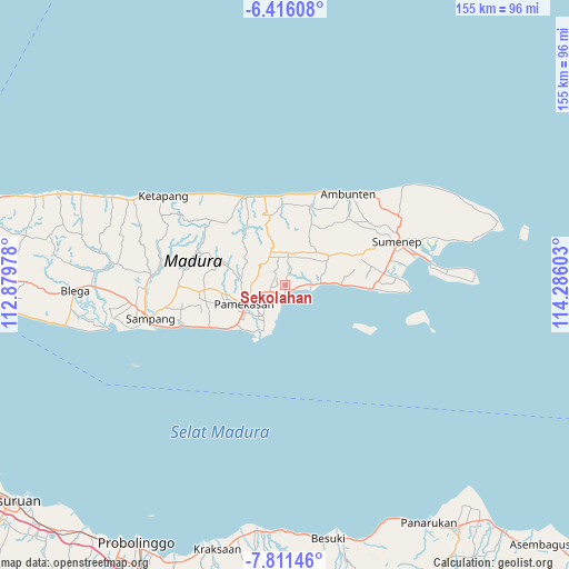
Sekolahan GPS coordinates[2]
7° 6' 51.48" South, 113° 34' 58.44" East
| Map corner | latitude | longitude |
|---|---|---|
| Upper-left | -6.41608°, | 112.87978° |
| Center: | -7.1143°, | 113.5829° |
| Lower-right: | -7.81146°, | 114.28603° |
| Map W x H: | 155.2×155.2 km | = 96.4×96.4mi |
| max Lat: | 5.88969° ⇑40.6% North |
| Sekolahan: | -7.1143° |
| min Lat: | ⇓59.4% South -10.934° |
| min Long | Sekolahan | max Long |
| 95.1345° | 113.5829° | 140.9419° |
| W 63.3%⇐ | ⇒36.7% E |
Elevation
Elevation of Sekolahan is 57 m = 187 ft, and this is 172.7 m = 567 ft below average elevation for this country.
| Max E: |
3185 m = 10449 ft | 60.6% |
| Avg. | 229.7 m = 754 ft | |
| Sekolahan | 57 m = 187 ft | |
Min E: |
-1 m = -3 ft | 39.4% |
See also: Indonesia elevation on elevation.city.
Geographical zone
Sekolahan is located in South Torrid zone (between Equator and Tropic of Capricorn). Distance of Equator is 791 km =491.5 mi to North.| Distance of | km | miles | from Sekolahan |
|---|---|---|---|
| Equator | 791 | 491.5 | to North |
| Tropic Capricorn | 1814.9 | 1127.7 | to South |
| Antarctic Circle | 6610.1 | 4107.3 | to South |
| South Pole | 9216 | 5726.6 | to South |


Nearby cities:
15 places around Sekolahan: (largest is in red/bold)
• Bakbatu
3.7 km =2.3 mi,  19°
19°
• Batuputih
3.4 km =2.1 mi,  262°
262°
• Bertah
3.8 km =2.4 mi,  268°
268°
• Daleman Tengah
1.4 km =0.9 mi,  41°
41°
• Gagah
1.5 km =0.9 mi,  59°
59°
• Kadur
3.6 km =2.2 mi,  311°
311°
• Mangkaan
3 km =1.9 mi,  69°
69°
• Pandiyan
3.4 km =2.1 mi,  235°
235°
• Panggulan
3.3 km =2.1 mi,  98°
98°
• Platok
1.8 km =1.1 mi,  194°
194°
• Polagan Tengah
3.6 km =2.2 mi,  222°
222°
• Raas
2.3 km =1.4 mi,  120°
120°
• Sumberngerjat
2.9 km =1.8 mi, 15°
• Tanahmerah
2.5 km =1.6 mi,  210°
210°
• Taraban Timur
0.6 km =0.4 mi, 263°
Sources, notices
• [Note1] Compared only with cities in Indonesia existing in our database
• [Src1] Map data: © OpenStreetMap contributors (CC-BY-SA)
• [Src2] Other city data from geonames.org with taken over terms of usage.
• [Src3] Geographical zone / Annual Mean Temperature by Robert A. Rohde @ Wikipedia
