Mojorejo geodata
Mojorejo (East Java) is a seat of a fourth-order administrative division; located in Indonesia in Asia/Jakarta (GMT+7) time zone. In our database, there are 407 cities with bigger population. Compared to other cities in Indonesia, 74.8% of cities are located further ↑North; 52.8% of cities are located further ←West and 77.9% of cities have lower elevation than Mojorejo. Note1


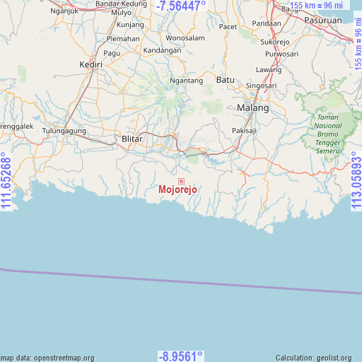
Mojorejo GPS coordinates[2]
8° 15' 39.24" South, 112° 21' 20.88" East
| Map corner | latitude | longitude |
|---|---|---|
| Upper-left | -7.56447°, | 111.65268° |
| Center: | -8.2609°, | 112.3558° |
| Lower-right: | -8.9561°, | 113.05893° |
| Map W x H: | 154.7×154.7 km | = 96.1×96.1mi |
| max Lat: | 5.88969° ⇑74.8% North |
| Mojorejo: | -8.2609° |
| min Lat: | ⇓25.2% South -10.934° |
| min Long | Mojorejo | max Long |
| 95.1345° | 112.3558° | 140.9419° |
| W 52.8%⇐ | ⇒47.2% E |
Elevation
Elevation of Mojorejo is 396 m = 1299 ft, and this is 166.3 m = 546 ft above average elevation for this country.
| Max E: |
3185 m = 10449 ft | 22.1% |
| Mojorejo | 396 m 1299 ft | |
| Avg. | 229.7 m = 754 ft | |
Min E: |
-1 m = -3 ft | 77.9% |
See also: Indonesia elevation on elevation.city.
Geographical zone
Mojorejo is located in South Torrid zone (between Equator and Tropic of Capricorn). Distance of Equator is 918.5 km =570.7 mi to North.| Distance of | km | miles | from Mojorejo |
|---|---|---|---|
| Equator | 918.5 | 570.7 | to North |
| Tropic Capricorn | 1687.4 | 1048.5 | to South |
| Antarctic Circle | 6482.6 | 4028.1 | to South |
| South Pole | 9088.5 | 5647.3 | to South |


Nearby cities:
15 places around Mojorejo: (largest is in red/bold)
• Balerejo
6.2 km =3.9 mi,  276°
276°
• Binangun
3.7 km =2.3 mi,  323°
323°
• Birowo
4.4 km =2.7 mi,  14°
14°
• Kalisangkrah Lor
4.5 km =2.8 mi,  126°
126°
• Krajan Kulon Purworejo
5.2 km =3.2 mi,  123°
123°
• Purworejo
3.7 km =2.3 mi,  256°
256°
• Ringinrejo
1.9 km =1.2 mi,  205°
205°
• Salamrejo
6 km =3.7 mi,  311°
311°
• Sambigede
6.4 km =4 mi,  346°
346°
• Sukomulyo
5 km =3.1 mi,  32°
32°
• Sukorejo
1.7 km =1.1 mi,  161°
161°
• Sumberarum
2.2 km =1.4 mi, 306°
• Tugurejo Satu
4.1 km =2.5 mi,  139°
139°
• Tulungrejo
3 km =1.9 mi,  250°
250°
• Wates
2.4 km =1.5 mi,  70°
70°
Sources, notices
• [Note1] Compared only with cities in Indonesia existing in our database
• [Src1] Map data: © OpenStreetMap contributors (CC-BY-SA)
• [Src2] Other city data from geonames.org with taken over terms of usage.
• [Src3] Geographical zone / Annual Mean Temperature by Robert A. Rohde @ Wikipedia
