Tulungrejo geodata
Tulungrejo (East Java) is a seat of a fourth-order administrative division; located in Indonesia in Asia/Jakarta (GMT+7) time zone. In our database, there are 407 cities with bigger population. Compared to other cities in Indonesia, 75.3% of cities are located further ↑North; 52.5% of cities are located further ←West and 73% of cities have lower elevation than Tulungrejo. Note1


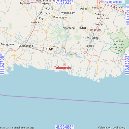
Tulungrejo GPS coordinates[2]
8° 16' 10.92" South, 112° 19' 48.72" East
| Map corner | latitude | longitude |
|---|---|---|
| Upper-left | -7.57329°, | 111.62708° |
| Center: | -8.2697°, | 112.3302° |
| Lower-right: | -8.96488°, | 113.03333° |
| Map W x H: | 154.7×154.7 km | = 96.1×96.1mi |
| max Lat: | 5.88969° ⇑75.3% North |
| Tulungrejo: | -8.2697° |
| min Lat: | ⇓24.7% South -10.934° |
| min Long | Tulungrejo | max Long |
| 95.1345° | 112.3302° | 140.9419° |
| W 52.5%⇐ | ⇒47.5% E |
Elevation
Elevation of Tulungrejo is 334 m = 1096 ft, and this is 104.3 m = 342 ft above average elevation for this country.
| Max E: |
3185 m = 10449 ft | 27% |
| Tulungrejo | 334 m 1096 ft | |
| Avg. | 229.7 m = 754 ft | |
Min E: |
-1 m = -3 ft | 73% |
See also: Indonesia elevation on elevation.city.
Geographical zone
Tulungrejo is located in South Torrid zone (between Equator and Tropic of Capricorn). Distance of Equator is 919.5 km =571.4 mi to North.| Distance of | km | miles | from Tulungrejo |
|---|---|---|---|
| Equator | 919.5 | 571.4 | to North |
| Tropic Capricorn | 1686.4 | 1047.9 | to South |
| Antarctic Circle | 6481.7 | 4027.5 | to South |
| South Pole | 9087.6 | 5646.8 | to South |


Nearby cities:
15 places around Tulungrejo: (largest is in red/bold)
• Balerejo
3.7 km =2.3 mi,  297°
297°
• Binangun
4 km =2.5 mi,  9°
9°
• Birowo
6.6 km =4.1 mi,  37°
37°
• Kaligambir
6.1 km =3.8 mi,  260°
260°
• Kalisangkrah Lor
6.6 km =4.1 mi,  105°
105°
• Mojorejo
3 km =1.9 mi,  70°
70°
• Panggungrejo
6 km =3.7 mi,  289°
289°
• Panggungwinong
5.8 km =3.6 mi,  305°
305°
• Purworejo
0.8 km =0.5 mi,  279°
279°
• Ringinrejo
2.1 km =1.3 mi, 110°
• Salamrejo
5.2 km =3.2 mi,  340°
340°
• Sukorejo
3.4 km =2.1 mi,  100°
100°
• Sumberarum
2.5 km =1.6 mi,  23°
23°
• Tugurejo Satu
5.9 km =3.7 mi, 111°
• Wates
5.4 km =3.4 mi, 70°
Sources, notices
• [Note1] Compared only with cities in Indonesia existing in our database
• [Src1] Map data: © OpenStreetMap contributors (CC-BY-SA)
• [Src2] Other city data from geonames.org with taken over terms of usage.
• [Src3] Geographical zone / Annual Mean Temperature by Robert A. Rohde @ Wikipedia
