Salamrejo geodata
Salamrejo (East Java) is a seat of a fourth-order administrative division; located in Indonesia in Asia/Jakarta (GMT+7) time zone. In our database, there are 407 cities with bigger population. Compared to other cities in Indonesia, 73.1% of cities are located further ↑North; 52.4% of cities are located further ←West and 65.5% of cities have lower elevation than Salamrejo. Note1


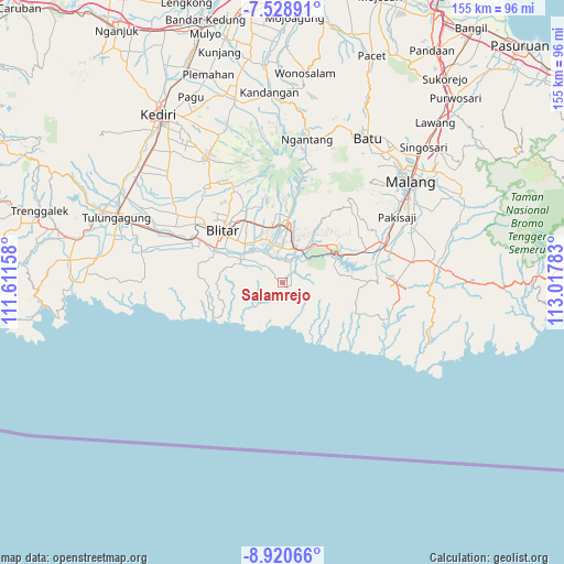
Salamrejo GPS coordinates[2]
8° 13' 31.44" South, 112° 18' 52.92" East
| Map corner | latitude | longitude |
|---|---|---|
| Upper-left | -7.52891°, | 111.61158° |
| Center: | -8.2254°, | 112.3147° |
| Lower-right: | -8.92066°, | 113.01783° |
| Map W x H: | 154.7×154.8 km | = 96.1×96.2mi |
| max Lat: | 5.88969° ⇑73.1% North |
| Salamrejo: | -8.2254° |
| min Lat: | ⇓26.9% South -10.934° |
| min Long | Salamrejo | max Long |
| 95.1345° | 112.3147° | 140.9419° |
| W 52.4%⇐ | ⇒47.6% E |
Elevation
Elevation of Salamrejo is 229 m = 751 ft, and this is 0.69999999999999 m = 2 ft below average elevation for this country.
| Max E: |
3185 m = 10449 ft | 34.5% |
| Avg. | 229.7 m = 754 ft | |
| Salamrejo | 229 m = 751 ft | |
Min E: |
-1 m = -3 ft | 65.5% |
See also: Indonesia elevation on elevation.city.
Geographical zone
Salamrejo is located in South Torrid zone (between Equator and Tropic of Capricorn). Distance of Equator is 914.6 km =568.3 mi to North.| Distance of | km | miles | from Salamrejo |
|---|---|---|---|
| Equator | 914.6 | 568.3 | to North |
| Tropic Capricorn | 1691.3 | 1050.9 | to South |
| Antarctic Circle | 6486.6 | 4030.6 | to South |
| South Pole | 9092.5 | 5649.8 | to South |


Nearby cities:
15 places around Salamrejo: (largest is in red/bold)
• Balerejo
3.6 km =2.2 mi,  206°
206°
• Binangun
2.5 km =1.6 mi,  112°
112°
• Birowo
5.7 km =3.5 mi,  86°
86°
• Kedungwungu
6.2 km =3.9 mi,  347°
347°
• Mojorejo
6 km =3.7 mi,  131°
131°
• Ngembul
6 km =3.7 mi,  18°
18°
• Panggungasri
2.7 km =1.7 mi,  310°
310°
• Panggungrejo
4.9 km =3 mi,  234°
234°
• Panggungwinong
3.3 km =2.1 mi,  242°
242°
• Purworejo
4.9 km =3 mi,  169°
169°
• Rampalombo
6.2 km =3.9 mi,  298°
298°
• Rejoso
3.9 km =2.4 mi,  36°
36°
• Sambigede
3.8 km =2.4 mi,  53°
53°
• Sumberarum
3.8 km =2.4 mi, 134°
• Tulungrejo
5.2 km =3.2 mi,  160°
160°
Sources, notices
• [Note1] Compared only with cities in Indonesia existing in our database
• [Src1] Map data: © OpenStreetMap contributors (CC-BY-SA)
• [Src2] Other city data from geonames.org with taken over terms of usage.
• [Src3] Geographical zone / Annual Mean Temperature by Robert A. Rohde @ Wikipedia
