Gagah geodata
Gagah (East Java) is a seat of a fourth-order administrative division; located in Indonesia in Asia/Jakarta (GMT+7) time zone. In our database, there are 407 cities with bigger population. Compared to other cities in Indonesia, 59.8% of cities are located further ↓South; 63.4% of cities are located further ←West and 61.1% of cities have higher elevation than Gagah. Note1


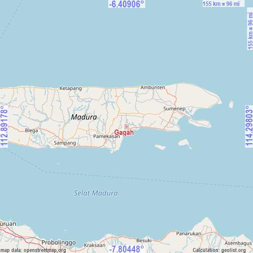
Gagah GPS coordinates[2]
7° 6' 26.28" South, 113° 35' 41.64" East
| Map corner | latitude | longitude |
|---|---|---|
| Upper-left | -6.40906°, | 112.89178° |
| Center: | -7.1073°, | 113.5949° |
| Lower-right: | -7.80448°, | 114.29803° |
| Map W x H: | 155.2×155.2 km | = 96.4×96.4mi |
| max Lat: | 5.88969° ⇑40.2% North |
| Gagah: | -7.1073° |
| min Lat: | ⇓59.8% South -10.934° |
| min Long | Gagah | max Long |
| 95.1345° | 113.5949° | 140.9419° |
| W 63.4%⇐ | ⇒36.6% E |
Elevation
Elevation of Gagah is 55 m = 180 ft, and this is 174.7 m = 573 ft below average elevation for this country.
| Max E: |
3185 m = 10449 ft | 61.1% |
| Avg. | 229.7 m = 754 ft | |
| Gagah | 55 m = 180 ft | |
Min E: |
-1 m = -3 ft | 38.9% |
See also: Indonesia elevation on elevation.city.
Geographical zone
Gagah is located in South Torrid zone (between Equator and Tropic of Capricorn). Distance of Equator is 790.3 km =491.1 mi to North.| Distance of | km | miles | from Gagah |
|---|---|---|---|
| Equator | 790.3 | 491.1 | to North |
| Tropic Capricorn | 1815.7 | 1128.2 | to South |
| Antarctic Circle | 6610.9 | 4107.8 | to South |
| South Pole | 9216.8 | 5727.1 | to South |


Nearby cities:
15 places around Gagah: (largest is in red/bold)
• Bakbatu
2.7 km =1.7 mi,  358°
358°
• Daleman Tengah
0.5 km =0.3 mi,  302°
302°
• Kadur
4.3 km =2.7 mi,  291°
291°
• Kolor
2.5 km =1.6 mi,  86°
86°
• Mangkaan
1.5 km =0.9 mi,  79°
79°
• Panggulan
2.3 km =1.4 mi,  123°
123°
• Platok
3.1 km =1.9 mi,  214°
214°
• Polay Atas
4.6 km =2.9 mi,  2°
2°
• Raas
2 km =1.2 mi,  162°
162°
• Sekolahan
1.5 km =0.9 mi,  239°
239°
• Sendang Timur
3.1 km =1.9 mi,  110°
110°
• Sumberngerjat
2.1 km =1.3 mi,  345°
345°
• Tanahmerah
3.9 km =2.4 mi,  221°
221°
• Taraban Timur
2.1 km =1.3 mi,  246°
246°
• Tengginan
3.7 km =2.3 mi, 84°
Sources, notices
• [Note1] Compared only with cities in Indonesia existing in our database
• [Src1] Map data: © OpenStreetMap contributors (CC-BY-SA)
• [Src2] Other city data from geonames.org with taken over terms of usage.
• [Src3] Geographical zone / Annual Mean Temperature by Robert A. Rohde @ Wikipedia
