Aduoen geodata
Aduoen (East Nusa Tenggara) is a seat of a fourth-order administrative division; located in Indonesia in Asia/Makassar (GMT+8) time zone. In our database, there are 407 cities with bigger population. Compared to other cities in Indonesia, 99.7% of cities are located further ↑North; 89.6% of cities are located further ←West and 81.9% of cities have higher elevation than Aduoen. Note1


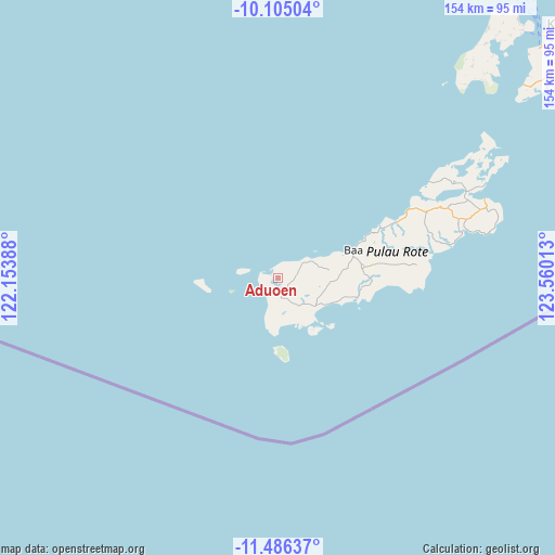
Aduoen GPS coordinates[2]
10° 47' 47.4" South, 122° 51' 25.2" East
| Map corner | latitude | longitude |
|---|---|---|
| Upper-left | -10.10504°, | 122.15388° |
| Center: | -10.7965°, | 122.857° |
| Lower-right: | -11.48637°, | 123.56013° |
| Map W x H: | 153.6×153.6 km | = 95.4×95.4mi |
| max Lat: | 5.88969° ⇑99.7% North |
| Aduoen: | -10.7965° |
| min Lat: | ⇓0.3% South -10.934° |
| min Long | Aduoen | max Long |
| 95.1345° | 122.857° | 140.9419° |
| W 89.6%⇐ | ⇒10.4% E |
Elevation
Elevation of Aduoen is 17 m = 56 ft, and this is 212.7 m = 698 ft below average elevation for this country.
| Max E: |
3185 m = 10449 ft | 81.9% |
| Avg. | 229.7 m = 754 ft | |
| Aduoen | 17 m = 56 ft | |
Min E: |
-1 m = -3 ft | 18.1% |
See also: Indonesia elevation on elevation.city.
Geographical zone
Aduoen is located in South Torrid zone (between Equator and Tropic of Capricorn). Distance of Equator is 1200.5 km =746 mi to North.| Distance of | km | miles | from Aduoen |
|---|---|---|---|
| Equator | 1200.5 | 746 | to North |
| Tropic Capricorn | 1405.5 | 873.3 | to South |
| Antarctic Circle | 6200.7 | 3852.9 | to South |
| South Pole | 8806.6 | 5472.2 | to South |


Nearby cities:
15 places around Aduoen: (largest is in red/bold)
• Faeanak Dua
9.5 km =5.9 mi,  89°
89°
• Kotafeuk
10.2 km =6.3 mi,  83°
83°
• Lalukoen Dua
10.6 km =6.6 mi,  134°
134°
• Leteki
12.5 km =7.8 mi,  156°
156°
• Lidor
8.3 km =5.2 mi, 130°
• Mbueaian
3.2 km =2 mi,  248°
248°
• Modosinal
11.4 km =7.1 mi, 89°
• Nemberala
10.5 km =6.5 mi,  198°
198°
• Netenain
11.4 km =7.1 mi,  72°
72°
• Oebaffok Satu
13.9 km =8.6 mi,  98°
98°
• Oehandi Utara
12.3 km =7.6 mi,  120°
120°
• Oelaba
7.7 km =4.8 mi,  51°
51°
• Olo
5.7 km =3.5 mi,  171°
171°
• Roioen
11.7 km =7.3 mi, 116°
• Sedeoen
9.7 km =6 mi, 197°
Sources, notices
• [Note1] Compared only with cities in Indonesia existing in our database
• [Src1] Map data: © OpenStreetMap contributors (CC-BY-SA)
• [Src2] Other city data from geonames.org with taken over terms of usage.
• [Src3] Geographical zone / Annual Mean Temperature by Robert A. Rohde @ Wikipedia
