Roioen geodata
Roioen (East Nusa Tenggara) is a seat of a fourth-order administrative division; located in Indonesia in Asia/Makassar (GMT+8) time zone. In our database, there are 407 cities with bigger population. Compared to other cities in Indonesia, 99.8% of cities are located further ↑North; 89.9% of cities are located further ←West and 51.9% of cities have lower elevation than Roioen. Note1


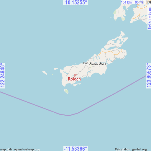
Roioen GPS coordinates[2]
10° 50' 38.04" South, 122° 57' 9.36" East
| Map corner | latitude | longitude |
|---|---|---|
| Upper-left | -10.15255°, | 122.24948° |
| Center: | -10.8439°, | 122.9526° |
| Lower-right: | -11.53366°, | 123.65573° |
| Map W x H: | 153.6×153.6 km | = 95.4×95.4mi |
| max Lat: | 5.88969° ⇑99.8% North |
| Roioen: | -10.8439° |
| min Lat: | ⇓0.2% South -10.934° |
| min Long | Roioen | max Long |
| 95.1345° | 122.9526° | 140.9419° |
| W 89.9%⇐ | ⇒10.1% E |
Elevation
Elevation of Roioen is 109 m = 358 ft, and this is 120.7 m = 396 ft below average elevation for this country.
| Max E: |
3185 m = 10449 ft | 48.1% |
| Avg. | 229.7 m = 754 ft | |
| Roioen | 109 m = 358 ft | |
Min E: |
-1 m = -3 ft | 51.9% |
See also: Indonesia elevation on elevation.city.
Geographical zone
Roioen is located in South Torrid zone (between Equator and Tropic of Capricorn). Distance of Equator is 1205.7 km =749.2 mi to North.| Distance of | km | miles | from Roioen |
|---|---|---|---|
| Equator | 1205.7 | 749.2 | to North |
| Tropic Capricorn | 1400.2 | 870 | to South |
| Antarctic Circle | 6195.4 | 3849.6 | to South |
| South Pole | 8801.3 | 5468.9 | to South |


Nearby cities:
15 places around Roioen: (largest is in red/bold)
• Batutua
3.9 km =2.4 mi,  116°
116°
• Batutua Satu
3.8 km =2.4 mi, 119°
• Busalangga
7.1 km =4.4 mi,  51°
51°
• Deranitan
6.8 km =4.2 mi,  106°
106°
• Faeanak Dua
5.4 km =3.4 mi,  349°
349°
• Inggudale
5.1 km =3.2 mi,  96°
96°
• Kotafeuk
6.4 km =4 mi,  357°
357°
• Lalukoen Dua
3.6 km =2.2 mi,  232°
232°
• Lidor
4.1 km =2.5 mi,  267°
267°
• Modosinal
5.5 km =3.4 mi,  10°
10°
• Nggalai Barat
7.5 km =4.7 mi,  77°
77°
• Oebaffok Satu
4.7 km =2.9 mi, 45°
• Oebatu
7.4 km =4.6 mi,  63°
63°
• Oebou
6.2 km =3.9 mi,  190°
190°
• Oehandi Utara
0.9 km =0.6 mi,  168°
168°
Sources, notices
• [Note1] Compared only with cities in Indonesia existing in our database
• [Src1] Map data: © OpenStreetMap contributors (CC-BY-SA)
• [Src2] Other city data from geonames.org with taken over terms of usage.
• [Src3] Geographical zone / Annual Mean Temperature by Robert A. Rohde @ Wikipedia
