Sedeoen geodata
Sedeoen (East Nusa Tenggara) is a seat of a fourth-order administrative division; located in Indonesia in Asia/Makassar (GMT+8) time zone. In our database, there are 407 cities with bigger population. Compared to other cities in Indonesia, 99.9% of cities are located further ↑North; 89.5% of cities are located further ←West and 86.4% of cities have higher elevation than Sedeoen. Note1


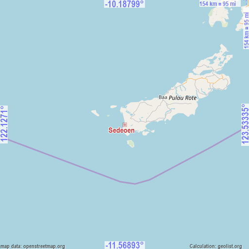
Sedeoen GPS coordinates[2]
10° 52' 45.336" South, 122° 49' 48.792" East
| Map corner | latitude | longitude |
|---|---|---|
| Upper-left | -10.18799°, | 122.1271° |
| Center: | -10.87926°, | 122.83022° |
| Lower-right: | -11.56893°, | 123.53335° |
| Map W x H: | 153.5×153.5 km | = 95.4×95.4mi |
| max Lat: | 5.88969° ⇑99.9% North |
| Sedeoen: | -10.87926° |
| min Lat: | ⇓0.1% South -10.934° |
| min Long | Sedeoen | max Long |
| 95.1345° | 122.83022° | 140.9419° |
| W 89.5%⇐ | ⇒10.5% E |
Elevation
Elevation of Sedeoen is 13 m = 43 ft, and this is 216.7 m = 711 ft below average elevation for this country.
| Max E: |
3185 m = 10449 ft | 86.4% |
| Avg. | 229.7 m = 754 ft | |
| Sedeoen | 13 m = 43 ft | |
Min E: |
-1 m = -3 ft | 13.6% |
See also: Indonesia elevation on elevation.city.
Geographical zone
Sedeoen is located in South Torrid zone (between Equator and Tropic of Capricorn). Distance of Equator is 1209.7 km =751.7 mi to North.| Distance of | km | miles | from Sedeoen |
|---|---|---|---|
| Equator | 1209.7 | 751.7 | to North |
| Tropic Capricorn | 1396.3 | 867.6 | to South |
| Antarctic Circle | 6191.5 | 3847.2 | to South |
| South Pole | 8797.4 | 5466.4 | to South |


Nearby cities:
15 places around Sedeoen: (largest is in red/bold)
• Aduoen
9.7 km =6 mi,  17°
17°
• Faeanak Dua
15.4 km =9.6 mi,  53°
53°
• Kotafeuk
16.6 km =10.3 mi, 51°
• Lalukoen Dua
10.7 km =6.6 mi,  80°
80°
• Leteki
8.1 km =5 mi,  106°
106°
• Lidor
10 km =6.2 mi,  67°
67°
• Mbueaian
8 km =5 mi,  359°
359°
• Nemberala
0.9 km =0.6 mi,  212°
212°
• Oebou
12.5 km =7.8 mi,  99°
99°
• Oehandi Utara
13.9 km =8.6 mi, 77°
• Oelaba
16.6 km =10.3 mi,  32°
32°
• Oemau
6.4 km =4 mi,  162°
162°
• Olo
5.2 km =3.2 mi, 46°
• Roioen
13.9 km =8.6 mi, 73°
• Tunggaoen Timur
4.9 km =3 mi,  182°
182°
Sources, notices
• [Note1] Compared only with cities in Indonesia existing in our database
• [Src1] Map data: © OpenStreetMap contributors (CC-BY-SA)
• [Src2] Other city data from geonames.org with taken over terms of usage.
• [Src3] Geographical zone / Annual Mean Temperature by Robert A. Rohde @ Wikipedia
