Lobuk geodata
Lobuk (East Java) is a seat of a fourth-order administrative division; located in Indonesia in Asia/Jakarta (GMT+7) time zone. In our database, there are 407 cities with bigger population. Compared to other cities in Indonesia, 58.7% of cities are located further ↓South; 65.7% of cities are located further ←West and 78.9% of cities have higher elevation than Lobuk. Note1


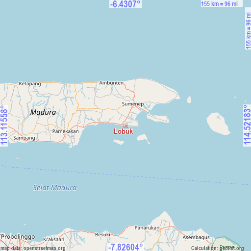
Lobuk GPS coordinates[2]
7° 7' 44.04" South, 113° 49' 7.32" East
| Map corner | latitude | longitude |
|---|---|---|
| Upper-left | -6.4307°, | 113.11558° |
| Center: | -7.1289°, | 113.8187° |
| Lower-right: | -7.82604°, | 114.52183° |
| Map W x H: | 155.1×155.2 km | = 96.4×96.4mi |
| max Lat: | 5.88969° ⇑41.3% North |
| Lobuk: | -7.1289° |
| min Lat: | ⇓58.7% South -10.934° |
| min Long | Lobuk | max Long |
| 95.1345° | 113.8187° | 140.9419° |
| W 65.7%⇐ | ⇒34.3% E |
Elevation
Elevation of Lobuk is 20 m = 66 ft, and this is 209.7 m = 688 ft below average elevation for this country.
| Max E: |
3185 m = 10449 ft | 78.9% |
| Avg. | 229.7 m = 754 ft | |
| Lobuk | 20 m = 66 ft | |
Min E: |
-1 m = -3 ft | 21.1% |
See also: Indonesia elevation on elevation.city.
Geographical zone
Lobuk is located in South Torrid zone (between Equator and Tropic of Capricorn). Distance of Equator is 792.7 km =492.6 mi to North.| Distance of | km | miles | from Lobuk |
|---|---|---|---|
| Equator | 792.7 | 492.6 | to North |
| Tropic Capricorn | 1813.3 | 1126.7 | to South |
| Antarctic Circle | 6608.5 | 4106.3 | to South |
| South Pole | 9214.4 | 5725.6 | to South |


Nearby cities:
15 places around Lobuk: (largest is in red/bold)
• Aenganyar
11 km =6.8 mi,  128°
128°
• Biyan
10.8 km =6.7 mi,  280°
280°
• Budan Daja
11.4 km =7.1 mi, 132°
• Kalangmangga
11.4 km =7.1 mi,  200°
200°
• Pagarbatu
4.7 km =2.9 mi,  95°
95°
• Palebunan
10.4 km =6.5 mi,  39°
39°
• Pesisir
7.9 km =4.9 mi, 281°
• Sasar
10.6 km =6.6 mi,  298°
298°
• Solok
10.5 km =6.5 mi,  309°
309°
• Solok Timur
11 km =6.8 mi, 314°
• Sukarame
11.1 km =6.9 mi,  207°
207°
• Sumberpandan
11.4 km =7.1 mi, 281°
• Sumuragung
10.8 km =6.7 mi, 201°
• Taman
11 km =6.8 mi,  192°
192°
• Taman
11.9 km =7.4 mi,  316°
316°
Sources, notices
• [Note1] Compared only with cities in Indonesia existing in our database
• [Src1] Map data: © OpenStreetMap contributors (CC-BY-SA)
• [Src2] Other city data from geonames.org with taken over terms of usage.
• [Src3] Geographical zone / Annual Mean Temperature by Robert A. Rohde @ Wikipedia
