Aenganyar geodata
Aenganyar (East Java) is a seat of a third-order administrative division; located in Indonesia in Asia/Jakarta (GMT+7) time zone. In our database, there are 407 cities with bigger population. Compared to other cities in Indonesia, 55.5% of cities are located further ↓South; 66.5% of cities are located further ←West and 78.1% of cities have higher elevation than Aenganyar. Note1


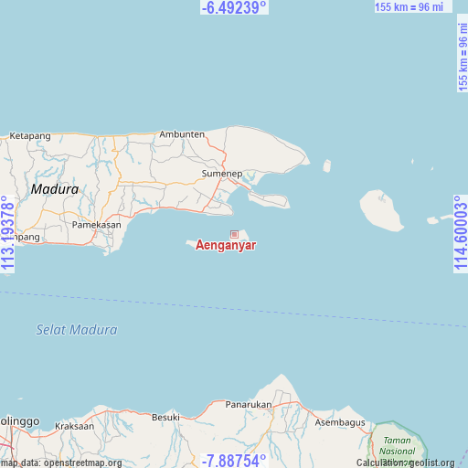
Aenganyar GPS coordinates[2]
7° 11' 25.8" South, 113° 53' 48.84" East
| Map corner | latitude | longitude |
|---|---|---|
| Upper-left | -6.49239°, | 113.19378° |
| Center: | -7.1905°, | 113.8969° |
| Lower-right: | -7.88754°, | 114.60003° |
| Map W x H: | 155.1×155.1 km | = 96.4×96.4mi |
| max Lat: | 5.88969° ⇑44.5% North |
| Aenganyar: | -7.1905° |
| min Lat: | ⇓55.5% South -10.934° |
| min Long | Aenganyar | max Long |
| 95.1345° | 113.8969° | 140.9419° |
| W 66.5%⇐ | ⇒33.5% E |
Elevation
Elevation of Aenganyar is 21 m = 69 ft, and this is 208.7 m = 685 ft below average elevation for this country.
| Max E: |
3185 m = 10449 ft | 78.1% |
| Avg. | 229.7 m = 754 ft | |
| Aenganyar | 21 m = 69 ft | |
Min E: |
-1 m = -3 ft | 21.9% |
See also: Indonesia elevation on elevation.city.
Geographical zone
Aenganyar is located in South Torrid zone (between Equator and Tropic of Capricorn). Distance of Equator is 799.5 km =496.8 mi to North.| Distance of | km | miles | from Aenganyar |
|---|---|---|---|
| Equator | 799.5 | 496.8 | to North |
| Tropic Capricorn | 1806.4 | 1122.4 | to South |
| Antarctic Circle | 6601.7 | 4102.1 | to South |
| South Pole | 9207.6 | 5721.3 | to South |


Nearby cities:
15 places around Aenganyar: (largest is in red/bold)
• Budan Daja
0.9 km =0.6 mi,  195°
195°
• Dadap
3.5 km =2.2 mi,  62°
62°
• Gapurana Daya
16.4 km =10.2 mi,  38°
38°
• Gedugan Barat
4 km =2.5 mi,  101°
101°
• Kalangmangga
13.2 km =8.2 mi,  253°
253°
• Kalianget
16 km =9.9 mi,  18°
18°
• Karengan
15.3 km =9.5 mi,  26°
26°
• Lobuk
11 km =6.8 mi,  308°
308°
• Pagarbatu
7.5 km =4.7 mi,  328°
328°
• Palebunan
15.1 km =9.4 mi,  352°
352°
• Sukarame
14.1 km =8.8 mi,  257°
257°
• Sumuragung
12.9 km =8 mi, 255°
• Sumurasin
13.5 km =8.4 mi, 20°
• Talango
15.4 km =9.6 mi, 22°
• Taman
11.6 km =7.2 mi, 250°
Sources, notices
• [Note1] Compared only with cities in Indonesia existing in our database
• [Src1] Map data: © OpenStreetMap contributors (CC-BY-SA)
• [Src2] Other city data from geonames.org with taken over terms of usage.
• [Src3] Geographical zone / Annual Mean Temperature by Robert A. Rohde @ Wikipedia
