Puamata geodata
Puamata (East Nusa Tenggara) is a seat of a fourth-order administrative division; located in Indonesia in Asia/Makassar (GMT+8) time zone. In our database, there are 407 cities with bigger population. Compared to other cities in Indonesia, 99.5% of cities are located further ↑North; 90.8% of cities are located further ←West and 63.7% of cities have lower elevation than Puamata. Note1


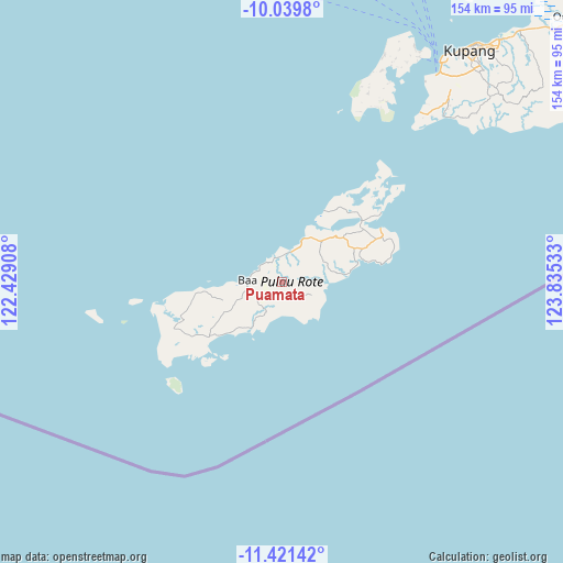
Puamata GPS coordinates[2]
10° 43' 53.04" South, 123° 7' 55.92" East
| Map corner | latitude | longitude |
|---|---|---|
| Upper-left | -10.0398°, | 122.42908° |
| Center: | -10.7314°, | 123.1322° |
| Lower-right: | -11.42142°, | 123.83533° |
| Map W x H: | 153.6×153.6 km | = 95.4×95.4mi |
| max Lat: | 5.88969° ⇑99.5% North |
| Puamata: | -10.7314° |
| min Lat: | ⇓0.5% South -10.934° |
| min Long | Puamata | max Long |
| 95.1345° | 123.1322° | 140.9419° |
| W 90.8%⇐ | ⇒9.2% E |
Elevation
Elevation of Puamata is 204 m = 669 ft, and this is 25.7 m = 84 ft below average elevation for this country.
| Max E: |
3185 m = 10449 ft | 36.3% |
| Avg. | 229.7 m = 754 ft | |
| Puamata | 204 m = 669 ft | |
Min E: |
-1 m = -3 ft | 63.7% |
See also: Indonesia elevation on elevation.city.
Geographical zone
Puamata is located in South Torrid zone (between Equator and Tropic of Capricorn). Distance of Equator is 1193.2 km =741.4 mi to North.| Distance of | km | miles | from Puamata |
|---|---|---|---|
| Equator | 1193.2 | 741.4 | to North |
| Tropic Capricorn | 1412.7 | 877.8 | to South |
| Antarctic Circle | 6208 | 3857.5 | to South |
| South Pole | 8813.8 | 5476.6 | to South |


Nearby cities:
15 places around Puamata: (largest is in red/bold)
• Alukama
9.5 km =5.9 mi,  262°
262°
• Baa
9.1 km =5.7 mi,  273°
273°
• Feapopi
6.4 km =4 mi,  339°
339°
• Kolla
8.6 km =5.3 mi,  18°
18°
• Kolobolon
7.9 km =4.9 mi,  177°
177°
• Lekik
5.8 km =3.6 mi,  217°
217°
• Likioen
9.8 km =6.1 mi, 258°
• Momanalu
7.7 km =4.8 mi,  7°
7°
• Nggenamadale
7.8 km =4.8 mi,  115°
115°
• Nitanggoeng
4.1 km =2.5 mi,  59°
59°
• Oele
6.7 km =4.2 mi,  153°
153°
• Oelunggu Satu
7.2 km =4.5 mi, 271°
• Potikosin
3.8 km =2.4 mi,  281°
281°
• Sanggaoen
10.4 km =6.5 mi,  248°
248°
• Seda
10.1 km =6.3 mi,  114°
114°
Sources, notices
• [Note1] Compared only with cities in Indonesia existing in our database
• [Src1] Map data: © OpenStreetMap contributors (CC-BY-SA)
• [Src2] Other city data from geonames.org with taken over terms of usage.
• [Src3] Geographical zone / Annual Mean Temperature by Robert A. Rohde @ Wikipedia
