Balung Barat geodata
Balung Barat (East Java) is a seat of a fourth-order administrative division; located in Indonesia in Asia/Jakarta (GMT+7) time zone. In our database, there are 407 cities with bigger population. Compared to other cities in Indonesia, 68.5% of cities are located further ↓South; 58% of cities are located further ←West and 92.1% of cities have higher elevation than Balung Barat. Note1


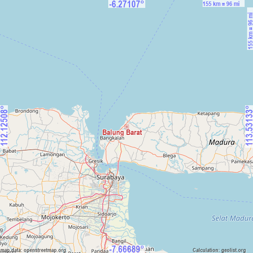
Balung Barat GPS coordinates[2]
6° 58' 10.2" South, 112° 49' 41.52" East
| Map corner | latitude | longitude |
|---|---|---|
| Upper-left | -6.27107°, | 112.12508° |
| Center: | -6.9695°, | 112.8282° |
| Lower-right: | -7.66689°, | 113.53133° |
| Map W x H: | 155.2×155.2 km | = 96.4×96.4mi |
| max Lat: | 5.88969° ⇑31.5% North |
| Balung Barat: | -6.9695° |
| min Lat: | ⇓68.5% South -10.934° |
| min Long | Balung Barat | max Long |
| 95.1345° | 112.8282° | 140.9419° |
| W 58%⇐ | ⇒42% E |
Elevation
Elevation of Balung Barat is 9 m = 30 ft, and this is 220.7 m = 724 ft below average elevation for this country.
| Max E: |
3185 m = 10449 ft | 92.1% |
| Avg. | 229.7 m = 754 ft | |
| Balung Barat | 9 m = 30 ft | |
Min E: |
-1 m = -3 ft | 7.9% |
See also: Indonesia elevation on elevation.city.
Geographical zone
Balung Barat is located in South Torrid zone (between Equator and Tropic of Capricorn). Distance of Equator is 774.9 km =481.5 mi to North.| Distance of | km | miles | from Balung Barat |
|---|---|---|---|
| Equator | 774.9 | 481.5 | to North |
| Tropic Capricorn | 1831 | 1137.7 | to South |
| Antarctic Circle | 6626.2 | 4117.3 | to South |
| South Pole | 9232.1 | 5736.6 | to South |


Nearby cities:
15 places around Balung Barat: (largest is in red/bold)
• Arosbaya
3.1 km =1.9 mi,  22°
22°
• Cendagah
3.1 km =1.9 mi,  63°
63°
• Dlemer
2.2 km =1.4 mi,  69°
69°
• Kalkal Barat
3.2 km =2 mi,  198°
198°
• Karangduwak
2.3 km =1.4 mi,  116°
116°
• Karangpao
3 km =1.9 mi, 56°
• Lancang
1.9 km =1.2 mi,  359°
359°
• Makamagung
2.6 km =1.6 mi, 59°
• Mangkon Daja
2.8 km =1.7 mi, 68°
• Mursaba
3.4 km =2.1 mi,  94°
94°
• Ombul Barat
2.2 km =1.4 mi,  161°
161°
• Panjun
2.8 km =1.7 mi,  184°
184°
• Pocokan Satu
2.7 km =1.7 mi,  259°
259°
• Tambeggan Satu
3.3 km =2.1 mi, 58°
• Ta’anyar
2.8 km =1.7 mi,  39°
39°
Sources, notices
• [Note1] Compared only with cities in Indonesia existing in our database
• [Src1] Map data: © OpenStreetMap contributors (CC-BY-SA)
• [Src2] Other city data from geonames.org with taken over terms of usage.
• [Src3] Geographical zone / Annual Mean Temperature by Robert A. Rohde @ Wikipedia
