Ombul Barat geodata
Ombul Barat (East Java) is a seat of a fourth-order administrative division; located in Indonesia in Asia/Jakarta (GMT+7) time zone. In our database, there are 407 cities with bigger population. Compared to other cities in Indonesia, 67.1% of cities are located further ↓South; 58% of cities are located further ←West and 84.2% of cities have higher elevation than Ombul Barat. Note1


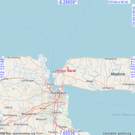
Ombul Barat GPS coordinates[2]
6° 59' 16.8" South, 112° 50' 4.56" East
| Map corner | latitude | longitude |
|---|---|---|
| Upper-left | -6.28959°, | 112.13148° |
| Center: | -6.988°, | 112.8346° |
| Lower-right: | -7.68536°, | 113.53773° |
| Map W x H: | 155.2×155.2 km | = 96.4×96.4mi |
| max Lat: | 5.88969° ⇑32.9% North |
| Ombul Barat: | -6.988° |
| min Lat: | ⇓67.1% South -10.934° |
| min Long | Ombul Barat | max Long |
| 95.1345° | 112.8346° | 140.9419° |
| W 58%⇐ | ⇒42% E |
Elevation
Elevation of Ombul Barat is 15 m = 49 ft, and this is 214.7 m = 704 ft below average elevation for this country.
| Max E: |
3185 m = 10449 ft | 84.2% |
| Avg. | 229.7 m = 754 ft | |
| Ombul Barat | 15 m = 49 ft | |
Min E: |
-1 m = -3 ft | 15.8% |
See also: Indonesia elevation on elevation.city.
Geographical zone
Ombul Barat is located in South Torrid zone (between Equator and Tropic of Capricorn). Distance of Equator is 777 km =482.8 mi to North.| Distance of | km | miles | from Ombul Barat |
|---|---|---|---|
| Equator | 777 | 482.8 | to North |
| Tropic Capricorn | 1828.9 | 1136.4 | to South |
| Antarctic Circle | 6624.2 | 4116.1 | to South |
| South Pole | 9230.1 | 5735.3 | to South |


Nearby cities:
15 places around Ombul Barat: (largest is in red/bold)
• Balung Barat
2.2 km =1.4 mi,  341°
341°
• Berbeluk Timur
4.3 km =2.7 mi,  49°
49°
• Cendagah
4 km =2.5 mi,  30°
30°
• Dlemer
3.1 km =1.9 mi, 25°
• Kalkal Barat
1.9 km =1.2 mi,  240°
240°
• Karangduwak
1.7 km =1.1 mi, 53°
• Karangpao
4.2 km =2.6 mi, 26°
• Lancang
4 km =2.5 mi,  349°
349°
• Makamagung
3.7 km =2.3 mi,  23°
23°
• Mangkon Daja
3.6 km =2.2 mi, 31°
• Mursaba
3.3 km =2.1 mi,  56°
56°
• Panjun
1.2 km =0.7 mi,  232°
232°
• Paobulan
1.3 km =0.8 mi,  140°
140°
• Pocokan Satu
3.7 km =2.3 mi,  295°
295°
• Ta’anyar
4.3 km =2.7 mi,  14°
14°
Sources, notices
• [Note1] Compared only with cities in Indonesia existing in our database
• [Src1] Map data: © OpenStreetMap contributors (CC-BY-SA)
• [Src2] Other city data from geonames.org with taken over terms of usage.
• [Src3] Geographical zone / Annual Mean Temperature by Robert A. Rohde @ Wikipedia
