Batambak geodata
Batambak (East Java) is a seat of a fourth-order administrative division; located in Indonesia in Asia/Jakarta (GMT+7) time zone. In our database, there are 407 cities with bigger population. Compared to other cities in Indonesia, 66.4% of cities are located further ↓South; 58.8% of cities are located further ←West and 52% of cities have lower elevation than Batambak. Note1


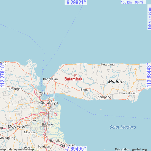
Batambak GPS coordinates[2]
6° 59' 51.36" South, 112° 58' 52.68" East
| Map corner | latitude | longitude |
|---|---|---|
| Upper-left | -6.29921°, | 112.27818° |
| Center: | -6.9976°, | 112.9813° |
| Lower-right: | -7.69495°, | 113.68443° |
| Map W x H: | 155.2×155.2 km | = 96.4×96.4mi |
| max Lat: | 5.88969° ⇑33.6% North |
| Batambak: | -6.9976° |
| min Lat: | ⇓66.4% South -10.934° |
| min Long | Batambak | max Long |
| 95.1345° | 112.9813° | 140.9419° |
| W 58.8%⇐ | ⇒41.2% E |
Elevation
Elevation of Batambak is 110 m = 361 ft, and this is 119.7 m = 393 ft below average elevation for this country.
| Max E: |
3185 m = 10449 ft | 48% |
| Avg. | 229.7 m = 754 ft | |
| Batambak | 110 m = 361 ft | |
Min E: |
-1 m = -3 ft | 52% |
See also: Indonesia elevation on elevation.city.
Geographical zone
Batambak is located in South Torrid zone (between Equator and Tropic of Capricorn). Distance of Equator is 778.1 km =483.5 mi to North.| Distance of | km | miles | from Batambak |
|---|---|---|---|
| Equator | 778.1 | 483.5 | to North |
| Tropic Capricorn | 1827.9 | 1135.8 | to South |
| Antarctic Circle | 6623.1 | 4115.4 | to South |
| South Pole | 9229 | 5734.6 | to South |


Nearby cities:
15 places around Batambak: (largest is in red/bold)
• Baratleke
5.5 km =3.4 mi,  17°
17°
• Cangkreng
4.1 km =2.5 mi,  324°
324°
• Gangseyan
7.2 km =4.5 mi,  327°
327°
• Kerbuyan
6.3 km =3.9 mi,  56°
56°
• Kokop
8.2 km =5.1 mi,  41°
41°
• Korogan Timur
8.9 km =5.5 mi, 35°
• Koronganayam
4.9 km =3 mi,  295°
295°
• Labang
6.2 km =3.9 mi,  335°
335°
• Longka
6 km =3.7 mi, 342°
• Mandepa Barat
2.6 km =1.6 mi,  68°
68°
• Pakes
3.6 km =2.2 mi,  6°
6°
• Palenggihan
7.1 km =4.4 mi, 303°
• Rukgaruk
5.3 km =3.3 mi,  25°
25°
• Sahplasah
3.7 km =2.3 mi, 30°
• Torsobih
8.2 km =5.1 mi,  92°
92°
Sources, notices
• [Note1] Compared only with cities in Indonesia existing in our database
• [Src1] Map data: © OpenStreetMap contributors (CC-BY-SA)
• [Src2] Other city data from geonames.org with taken over terms of usage.
• [Src3] Geographical zone / Annual Mean Temperature by Robert A. Rohde @ Wikipedia
