Sebegen geodata
Sebegen (East Java) is a seat of a fourth-order administrative division; located in Indonesia in Asia/Jakarta (GMT+7) time zone. In our database, there are 407 cities with bigger population. Compared to other cities in Indonesia, 69.7% of cities are located further ↓South; 59.9% of cities are located further ←West and 58.2% of cities have higher elevation than Sebegen. Note1


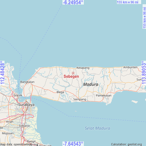
Sebegen GPS coordinates[2]
6° 56' 52.8" South, 113° 11' 14.64" East
| Map corner | latitude | longitude |
|---|---|---|
| Upper-left | -6.24954°, | 112.48428° |
| Center: | -6.948°, | 113.1874° |
| Lower-right: | -7.64543°, | 113.89053° |
| Map W x H: | 155.2×155.2 km | = 96.4×96.4mi |
| max Lat: | 5.88969° ⇑30.3% North |
| Sebegen: | -6.948° |
| min Lat: | ⇓69.7% South -10.934° |
| min Long | Sebegen | max Long |
| 95.1345° | 113.1874° | 140.9419° |
| W 59.9%⇐ | ⇒40.1% E |
Elevation
Elevation of Sebegen is 67 m = 220 ft, and this is 162.7 m = 534 ft below average elevation for this country.
| Max E: |
3185 m = 10449 ft | 58.2% |
| Avg. | 229.7 m = 754 ft | |
| Sebegen | 67 m = 220 ft | |
Min E: |
-1 m = -3 ft | 41.8% |
See also: Indonesia elevation on elevation.city.
Geographical zone
Sebegen is located in South Torrid zone (between Equator and Tropic of Capricorn). Distance of Equator is 772.5 km =480 mi to North.| Distance of | km | miles | from Sebegen |
|---|---|---|---|
| Equator | 772.5 | 480 | to North |
| Tropic Capricorn | 1833.4 | 1139.2 | to South |
| Antarctic Circle | 6628.6 | 4118.8 | to South |
| South Pole | 9234.5 | 5738.1 | to South |


Nearby cities:
15 places around Sebegen: (largest is in red/bold)
• Baih
6.3 km =3.9 mi,  246°
246°
• Bateke
2.1 km =1.3 mi,  218°
218°
• Galis
4.3 km =2.7 mi,  119°
119°
• Kapasan
5.4 km =3.4 mi,  358°
358°
• Korbukor
2.8 km =1.7 mi,  11°
11°
• Mandeman Daya
6.3 km =3.9 mi,  327°
327°
• Morbatoh
4.2 km =2.6 mi, 325°
• Pandian
5.9 km =3.7 mi,  306°
306°
• Ramaram
5.8 km =3.6 mi,  341°
341°
• Tapaan Timur
2.6 km =1.6 mi,  259°
259°
• Taposan
1.8 km =1.1 mi,  233°
233°
• Tebanah
3.5 km =2.2 mi,  32°
32°
• Tenggina Daya
1.6 km =1 mi,  142°
142°
• Tiara
5.9 km =3.7 mi,  278°
278°
• Tlagah Timur
4.6 km =2.9 mi,  37°
37°
Sources, notices
• [Note1] Compared only with cities in Indonesia existing in our database
• [Src1] Map data: © OpenStreetMap contributors (CC-BY-SA)
• [Src2] Other city data from geonames.org with taken over terms of usage.
• [Src3] Geographical zone / Annual Mean Temperature by Robert A. Rohde @ Wikipedia
