Oeri’u geodata
Oeri’u (East Nusa Tenggara) is a seat of a fourth-order administrative division; located in Indonesia in Asia/Makassar (GMT+8) time zone. In our database, there are 407 cities with bigger population. Compared to other cities in Indonesia, 98.7% of cities are located further ↑North; 93.4% of cities are located further ←West and 72% of cities have lower elevation than Oeri’u. Note1


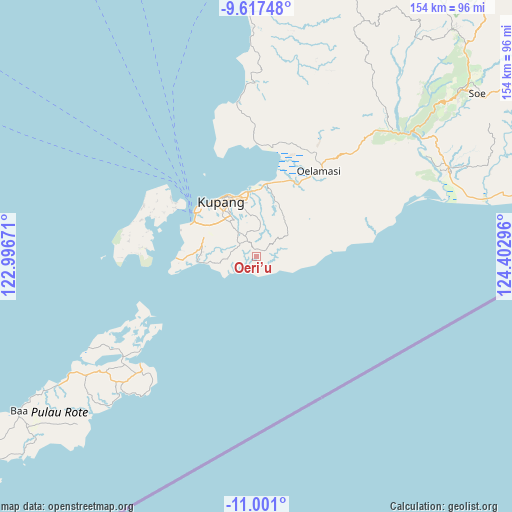
Oeri’u GPS coordinates[2]
10° 18' 36" South, 123° 41' 59.388" East
| Map corner | latitude | longitude |
|---|---|---|
| Upper-left | -9.61748°, | 122.99671° |
| Center: | -10.31°, | 123.69983° |
| Lower-right: | -11.001°, | 124.40296° |
| Map W x H: | 153.8×153.8 km | = 95.6×95.6mi |
| max Lat: | 5.88969° ⇑98.7% North |
| Oeri’u: | -10.31° |
| min Lat: | ⇓1.3% South -10.934° |
| min Long | Oeri’u | max Long |
| 95.1345° | 123.69983° | 140.9419° |
| W 93.4%⇐ | ⇒6.6% E |
Elevation
Elevation of Oeri’u is 321 m = 1053 ft, and this is 91.3 m = 300 ft above average elevation for this country.
| Max E: |
3185 m = 10449 ft | 28% |
| Oeri’u | 321 m 1053 ft | |
| Avg. | 229.7 m = 754 ft | |
Min E: |
-1 m = -3 ft | 72% |
See also: Indonesia elevation on elevation.city.
Geographical zone
Oeri’u is located in South Torrid zone (between Equator and Tropic of Capricorn). Distance of Equator is 1146.4 km =712.3 mi to North.| Distance of | km | miles | from Oeri’u |
|---|---|---|---|
| Equator | 1146.4 | 712.3 | to North |
| Tropic Capricorn | 1459.6 | 907 | to South |
| Antarctic Circle | 6254.8 | 3886.6 | to South |
| South Pole | 8860.7 | 5505.8 | to South |


Nearby cities:
15 places around Oeri’u: (largest is in red/bold)
• Baun
3.3 km =2.1 mi,  57°
57°
• Bieto
2.3 km =1.4 mi,  1°
1°
• Kiupakas
6.1 km =3.8 mi,  311°
311°
• Kolomanu
7.6 km =4.7 mi,  359°
359°
• Mukifeto
8.7 km =5.4 mi,  265°
265°
• Nonpuah
7 km =4.3 mi,  330°
330°
• Oehani
8.8 km =5.5 mi,  6°
6°
• Oekuu
9.8 km =6.1 mi,  101°
101°
• Oesain
6.5 km =4 mi,  136°
136°
• Potibaun
5.8 km =3.6 mi,  48°
48°
• Soba
3.7 km =2.3 mi,  39°
39°
• Sonaf
1.8 km =1.1 mi,  128°
128°
• Tanenofunan
5.2 km =3.2 mi, 328°
• Tasikona
10.1 km =6.3 mi,  238°
238°
• Tualeu
8.4 km =5.2 mi, 325°
Sources, notices
• [Note1] Compared only with cities in Indonesia existing in our database
• [Src1] Map data: © OpenStreetMap contributors (CC-BY-SA)
• [Src2] Other city data from geonames.org with taken over terms of usage.
• [Src3] Geographical zone / Annual Mean Temperature by Robert A. Rohde @ Wikipedia
