Oesain geodata
Oesain (East Nusa Tenggara) is a seat of a fourth-order administrative division; located in Indonesia in Asia/Makassar (GMT+8) time zone. In our database, there are 407 cities with bigger population. Compared to other cities in Indonesia, 98.7% of cities are located further ↑North; 93.5% of cities are located further ←West and 76.2% of cities have higher elevation than Oesain. Note1


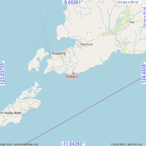
Oesain GPS coordinates[2]
10° 21' 10.908" South, 123° 44' 26.412" East
| Map corner | latitude | longitude |
|---|---|---|
| Upper-left | -9.66061°, | 123.03755° |
| Center: | -10.35303°, | 123.74067° |
| Lower-right: | -11.04393°, | 124.4438° |
| Map W x H: | 153.8×153.8 km | = 95.6×95.6mi |
| max Lat: | 5.88969° ⇑98.7% North |
| Oesain: | -10.35303° |
| min Lat: | ⇓1.3% South -10.934° |
| min Long | Oesain | max Long |
| 95.1345° | 123.74067° | 140.9419° |
| W 93.5%⇐ | ⇒6.5% E |
Elevation
Elevation of Oesain is 23 m = 75 ft, and this is 206.7 m = 678 ft below average elevation for this country.
| Max E: |
3185 m = 10449 ft | 76.2% |
| Avg. | 229.7 m = 754 ft | |
| Oesain | 23 m = 75 ft | |
Min E: |
-1 m = -3 ft | 23.8% |
See also: Indonesia elevation on elevation.city.
Geographical zone
Oesain is located in South Torrid zone (between Equator and Tropic of Capricorn). Distance of Equator is 1151.1 km =715.3 mi to North.| Distance of | km | miles | from Oesain |
|---|---|---|---|
| Equator | 1151.1 | 715.3 | to North |
| Tropic Capricorn | 1454.8 | 904 | to South |
| Antarctic Circle | 6250 | 3883.6 | to South |
| South Pole | 8855.9 | 5502.8 | to South |


Nearby cities:
15 places around Oesain: (largest is in red/bold)
• Batuna Satu
11.5 km =7.1 mi,  19°
19°
• Baun
6.8 km =4.2 mi,  345°
345°
• Bieto
8.4 km =5.2 mi,  328°
328°
• Habo
11.5 km =7.1 mi,  66°
66°
• Kiupakas
12.6 km =7.8 mi,  314°
314°
• Kolomanu
13.2 km =8.2 mi,  339°
339°
• Nonpuah
13.4 km =8.3 mi,  323°
323°
• Oekuu
5.9 km =3.7 mi,  60°
60°
• Oeri’u
6.5 km =4 mi, 316°
• Potibaun
8.6 km =5.3 mi,  359°
359°
• Soba
7.9 km =4.9 mi, 344°
• Sonaf
4.8 km =3 mi, 320°
• Sonraen
13.7 km =8.5 mi, 57°
• Tanenofunan
11.7 km =7.3 mi, 321°
• Tasikona
13.1 km =8.1 mi,  268°
268°
Sources, notices
• [Note1] Compared only with cities in Indonesia existing in our database
• [Src1] Map data: © OpenStreetMap contributors (CC-BY-SA)
• [Src2] Other city data from geonames.org with taken over terms of usage.
• [Src3] Geographical zone / Annual Mean Temperature by Robert A. Rohde @ Wikipedia
