Baun geodata
Baun (East Nusa Tenggara) is a seat of a fourth-order administrative division; located in Indonesia in Asia/Makassar (GMT+8) time zone. In our database, there are 407 cities with bigger population. Compared to other cities in Indonesia, 98.6% of cities are located further ↑North; 93.4% of cities are located further ←West and 81.2% of cities have lower elevation than Baun. Note1


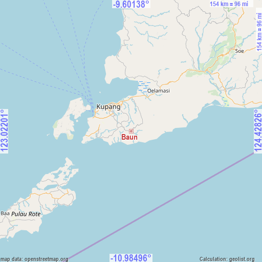
Baun GPS coordinates[2]
10° 17' 38.148" South, 123° 43' 30.468" East
| Map corner | latitude | longitude |
|---|---|---|
| Upper-left | -9.60138°, | 123.02201° |
| Center: | -10.29393°, | 123.72513° |
| Lower-right: | -10.98496°, | 124.42826° |
| Map W x H: | 153.8×153.8 km | = 95.6×95.6mi |
| max Lat: | 5.88969° ⇑98.6% North |
| Baun: | -10.29393° |
| min Lat: | ⇓1.4% South -10.934° |
| min Long | Baun | max Long |
| 95.1345° | 123.72513° | 140.9419° |
| W 93.4%⇐ | ⇒6.6% E |
Elevation
Elevation of Baun is 450 m = 1476 ft, and this is 220.3 m = 723 ft above average elevation for this country.
| Max E: |
3185 m = 10449 ft | 18.8% |
| Baun | 450 m 1476 ft | |
| Avg. | 229.7 m = 754 ft | |
Min E: |
-1 m = -3 ft | 81.2% |
See also: Indonesia elevation on elevation.city.
Geographical zone
Baun is located in South Torrid zone (between Equator and Tropic of Capricorn). Distance of Equator is 1144.6 km =711.2 mi to North.| Distance of | km | miles | from Baun |
|---|---|---|---|
| Equator | 1144.6 | 711.2 | to North |
| Tropic Capricorn | 1461.3 | 908 | to South |
| Antarctic Circle | 6256.6 | 3887.7 | to South |
| South Pole | 8862.5 | 5506.9 | to South |


Nearby cities:
15 places around Baun: (largest is in red/bold)
• Batuna Satu
7 km =4.3 mi,  51°
51°
• Bieto
2.8 km =1.7 mi,  281°
281°
• Kiupakas
7.6 km =4.7 mi,  286°
286°
• Kolomanu
6.5 km =4 mi,  333°
333°
• Nonpuah
7.6 km =4.7 mi,  304°
304°
• Oehani
7.2 km =4.5 mi,  346°
346°
• Oekuu
7.8 km =4.8 mi,  118°
118°
• Oeltua
10.4 km =6.5 mi, 329°
• Oeri’u
3.3 km =2.1 mi,  237°
237°
• Oesain
6.8 km =4.2 mi,  165°
165°
• Potibaun
2.5 km =1.6 mi,  37°
37°
• Soba
1.2 km =0.7 mi,  340°
340°
• Sonaf
3.2 km =2 mi,  204°
204°
• Tanenofunan
6.1 km =3.8 mi, 295°
• Tualeu
9.1 km =5.7 mi, 304°
Sources, notices
• [Note1] Compared only with cities in Indonesia existing in our database
• [Src1] Map data: © OpenStreetMap contributors (CC-BY-SA)
• [Src2] Other city data from geonames.org with taken over terms of usage.
• [Src3] Geographical zone / Annual Mean Temperature by Robert A. Rohde @ Wikipedia
